IMAGES TAKEN NEAR TO
Portsmouth Road, WOKING, GU23 7DB
Introduction
This page details the photographs taken nearby to Portsmouth Road, GU23 7DB by members of the Geograph project.
The Geograph project started in 2005 with the aim of publishing, organising and preserving representative images for every square kilometre of Great Britain, Ireland and the Isle of Man.

There are currently over 7.5m images from over14,400 individuals and you can help contribute to the project by visiting https://www.geograph.org.uk
Image Map
Images are licensed for reuse under creativecommons.org/licenses/by-sa/2.0
Notes
- Clicking on the map will re-center to the selected point.
- The higher the marker number, the further away the image location is from the centre of the postcode.
Image Listing (41 Images Found)
Images are licensed for reuse under creativecommons.org/licenses/by-sa/2.0
Image
Details
Distance
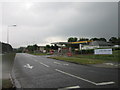
1
Looking from Send Barns Lane towards Burntcommon Garage
Image: © Basher Eyre
Taken: 15 Oct 2011
0.02 miles
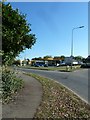
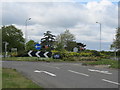
5
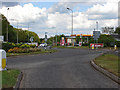
Burntcommon roundabout
The roundabout where the London Road meets Send Barns Road with the petrol station in the background.
Image: © Alan Hunt
Taken: 16 May 2013
0.03 miles
6
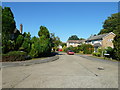
Looking from The Pathway into Birch Close
Image: © Basher Eyre
Taken: 15 Oct 2011
0.03 miles
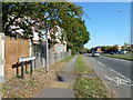
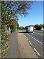
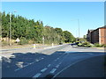
8
Looking across Portsmouth Road towards Boughton Hall Avenue
Image: © Basher Eyre
Taken: 15 Oct 2011
0.03 miles
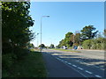
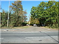
10
Junction of Portsmouth Road and the entrance to Milestone House
Image: © Basher Eyre
Taken: 15 Oct 2011
0.04 miles