IMAGES TAKEN NEAR TO
Long Reach, WOKING, GU23 6PF
Introduction
This page details the photographs taken nearby to Long Reach, GU23 6PF by members of the Geograph project.
The Geograph project started in 2005 with the aim of publishing, organising and preserving representative images for every square kilometre of Great Britain, Ireland and the Isle of Man.

There are currently over 7.5m images from over14,400 individuals and you can help contribute to the project by visiting https://www.geograph.org.uk
Image Map
Images are licensed for reuse under creativecommons.org/licenses/by-sa/2.0
Notes
- Clicking on the map will re-center to the selected point.
- The higher the marker number, the further away the image location is from the centre of the postcode.
Image Listing (9 Images Found)
Images are licensed for reuse under creativecommons.org/licenses/by-sa/2.0
Image
Details
Distance
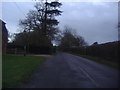
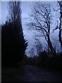
4
By South End Farm
Quiet country lane heading towards Ockham, lined by wooden fencing, hedgerows and paddocks.
Image: © Colin Smith
Taken: 11 Jan 2009
0.05 miles
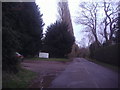
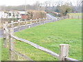
5
Entrance to farm off Long Reach, Ockham
Image: © David Howard
Taken: 12 Dec 2011
0.05 miles
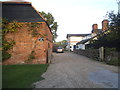
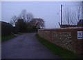
6
Shelter belt by Bachelors Farm
Tall trees lining the roadside and providing some protection from westerly winds.
Image: © Colin Smith
Taken: 11 Jan 2009
0.14 miles
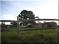
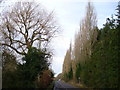
7
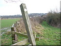
Footpath Near Church End
Heading south towards West Horsley, the path has a large block of concrete - presumably to deter non-pedestrian traffic. The fields have clay soils, going becoming soft as the thaw sets in.
Image: © Colin Smith
Taken: 11 Jan 2009
0.16 miles