IMAGES TAKEN NEAR TO
Chestnut Close, WOKING, GU23 6LJ
Introduction
This page details the photographs taken nearby to Chestnut Close, GU23 6LJ by members of the Geograph project.
The Geograph project started in 2005 with the aim of publishing, organising and preserving representative images for every square kilometre of Great Britain, Ireland and the Isle of Man.

There are currently over 7.5m images from over14,400 individuals and you can help contribute to the project by visiting https://www.geograph.org.uk
Image Map (Loading...)


Getting Data...Please wait
Leaflet Map data © OpenStreetMap
Images are licensed for reuse under creativecommons.org/licenses/by-sa/2.0
Notes
- Clicking on the map will re-center to the selected point.
- The higher the marker number, the further away the image location is from the centre of the postcode.
Image Listing (19 Images Found)
Images are licensed for reuse under creativecommons.org/licenses/by-sa/2.0
Image
Details
Distance
1
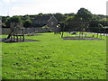
Playground, Maple Road, Send Marsh
Image: © Richard Rogerson
Taken: 30 Aug 2010
0.02 miles
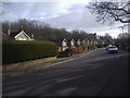
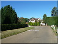
3
Looking north-west up Boughton Hall Avenue
Image: © Basher Eyre
Taken: 15 Oct 2011
0.20 miles
4

Old Milestone by the B2215, Portsmouth Road, Send parish
Carved stone post by the B2215 (was A3), in parish of SEND (GUILDFORD District), Portsmouth Road, by Conaught House (offices) Northeast of petrol station and traffic island, on cut grass verge, behind path, on Southeast side of road. Guildford facets, erected by the Kingston & Sheetbridge, 1st District turnpike trust in the 19th century.
Inscription reads:-
: GUILDFORD / 4 MILES : : PORTSMOUTH / 46 : : HYDE PARK CORNER / 23 : : RIPLEY / 2 MILES :
Carved benchmark on left side.
Milestone Society National ID: SY_LP23.
Image: © L Joseph
Taken: 1 Mar 2005
0.20 miles
5
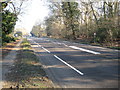
Send Marsh: B2215 Portsmouth Road
At one time this was the A3 arterial road from London to Portsmouth. However the opening of the Ripley Bypass has resulted in a downgrade to the B2215. The 1940s Ordnance Survey mapping shows the road as the A3 and Send Marsh spelt as one word. Garlick's Arch Copse is on the far side of the road.
Image: © Nigel Cox
Taken: 17 Feb 2008
0.20 miles
6
Looking from Portsmouth Road towards Milestone House
Image: © Basher Eyre
Taken: 15 Oct 2011
0.21 miles
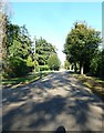
8
Looking eastwards in Boughton Hall Avenue
Image: © Basher Eyre
Taken: 15 Oct 2011
0.21 miles
9
Looking from Milestone House towards Portsmouth Road
Image: © Basher Eyre
Taken: 15 Oct 2011
0.21 miles
10
Road junction with Boughton Hall Avenue
Image: © Basher Eyre
Taken: 15 Oct 2011
0.22 miles