IMAGES TAKEN NEAR TO
Bonsey Close, WOKING, GU22 9PS
Introduction
This page details the photographs taken nearby to Bonsey Close, GU22 9PS by members of the Geograph project.
The Geograph project started in 2005 with the aim of publishing, organising and preserving representative images for every square kilometre of Great Britain, Ireland and the Isle of Man.

There are currently over 7.5m images from over14,400 individuals and you can help contribute to the project by visiting https://www.geograph.org.uk
Image Map
Images are licensed for reuse under creativecommons.org/licenses/by-sa/2.0
Notes
- Clicking on the map will re-center to the selected point.
- The higher the marker number, the further away the image location is from the centre of the postcode.
Image Listing (28 Images Found)
Images are licensed for reuse under creativecommons.org/licenses/by-sa/2.0
Image
Details
Distance
1
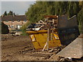
The Hoe Valley
A view across the working area of the Hoe Valley flood relief scheme with the houses on Willow Way in the background.
Image: © Alan Hunt
Taken: 1 Oct 2011
0.06 miles
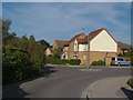
2
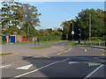
Bonsey Lane, Westfield
The junction of Bonsey Lane with Hoebrook Close (foreground) with Westfield Common on the right.
Image: © Alan Hunt
Taken: 1 Oct 2011
0.07 miles
3
Hoebrook Close, Westfield
A view along Hoebrook Close. The Westfield Primary School is out of shot on the right.
Image: © Alan Hunt
Taken: 1 Oct 2011
0.08 miles
4
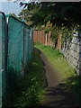
Footpath, Hoe Valley
The footpath that runs behind Maple Road with the fence of the Hoe Valley flood relief scheme on the left.
Image: © Alan Hunt
Taken: 1 Oct 2011
0.09 miles
5
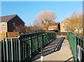
Foot Bridge over Hoe Stream
Hoe Stream becomes The Bourne downstream then flows into Abbey Stream part of the River Wey.
Image: © James Emmans
Taken: 19 Nov 2018
0.10 miles
6
Hoebrook Close
Hoebrook Close from the gate of the Adult Learning Centre.
Image: © Alan Hunt
Taken: 1 Oct 2011
0.12 miles
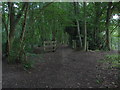
7
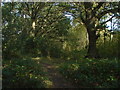
Westfield Common
A path through the trees on Westfield Common
Image: © Alan Hunt
Taken: 1 Oct 2011
0.14 miles
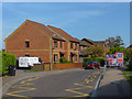
8
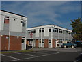
The Adult Education centre, Westfield
The classroom blocks of the education centre next door to the Westfield Primary School.
Image: © Alan Hunt
Taken: 1 Oct 2011
0.16 miles
9
Hoe valley, Woking
A footbridge over a drain feeding into the Hoe Stream.
Image: © Alan Hunt
Taken: 7 Aug 2011
0.16 miles
10
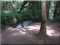
The Hoe Stream, Woking
A view of the stream in a wooded area of the Hoe Valley. It looks as if someone has tried to cut down the tree!
Image: © Alan Hunt
Taken: 7 Aug 2011
0.16 miles