IMAGES TAKEN NEAR TO
Campbell Avenue, WOKING, GU22 9NP
Introduction
This page details the photographs taken nearby to Campbell Avenue, GU22 9NP by members of the Geograph project.
The Geograph project started in 2005 with the aim of publishing, organising and preserving representative images for every square kilometre of Great Britain, Ireland and the Isle of Man.

There are currently over 7.5m images from over14,400 individuals and you can help contribute to the project by visiting https://www.geograph.org.uk
Image Map
Images are licensed for reuse under creativecommons.org/licenses/by-sa/2.0
Notes
- Clicking on the map will re-center to the selected point.
- The higher the marker number, the further away the image location is from the centre of the postcode.
Image Listing (22 Images Found)
Images are licensed for reuse under creativecommons.org/licenses/by-sa/2.0
Image
Details
Distance
1
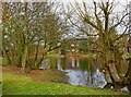
Pond on Westfield Common
Due to the heavy rainfall of the winter, the pond seems to have extended its area.
Image
Image: © P L Chadwick
Taken: 12 Mar 2010
0.13 miles
2
Pond on Westfield Common
The pond is near The Cricketers pub.
Image
Image: © P L Chadwick
Taken: 12 Mar 2010
0.13 miles
3
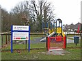
Westfield Common Play Area, near Balfour Avenue
On the edge of the common is this play area, suitable for children up to 12 years old.
Image
Image: © P L Chadwick
Taken: 12 Mar 2010
0.15 miles
4
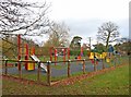
Westfield Common Play Area, near Balfour Avenue
On a cold wet March day the play area, not surprisingly, was completely deserted.
Image
Image: © P L Chadwick
Taken: 12 Mar 2010
0.15 miles
5
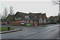
The Cricketers, Westfield Road
The pub is currently closed and not for the first time. It is a great shame, as it is in a nice position next to Westfield Common.
Image
Image
Image
Image: © P L Chadwick
Taken: 12 Mar 2010
0.15 miles
6
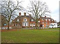
The Cricketers (side view), Westfield Road
Viewed from Westfield Common. Unfortunately the pub has again closed, and the building is up for sale. These are difficult times for pubs, so whether it will reopen as a pub is impossible to predict.
Image
Image
Image
Image: © P L Chadwick
Taken: 12 Mar 2010
0.15 miles
7
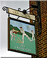
The Cricketers pub sign, Westfield Road
The pub's sign hangs on the side of the building, opposite to Westfield Common. An unusual design, it appears to show the batsman being hit in the eye by the ball, while in turn his bat is hitting the player behind him! If this currently closed pub doesn't reopen, this amusing sign is in danger of disappearing, and another snippet of local history will be gone.
Image
Image
Image
Image: © P L Chadwick
Taken: 12 Mar 2010
0.15 miles
8
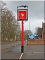
Courage sign outside The Cricketers, Westfield Road
These Courage Brewery signs used to be a familiar sight. However in recent years Courage went through several changes of ownership, and is no longer independent. Consequently the signs have been disappearing fast and the future of this one is debateable, as the pub is currently closed and for sale.
Image
Image: © P L Chadwick
Taken: 12 Mar 2010
0.15 miles
9
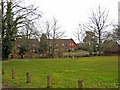
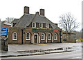
Moorcroft Centre in the Community, Old School Place
According to the local Council's Window on Woking website, this community centre offers: "Centre of Activities including Aromatherapy Massage, Reflexology and Indian Head Massage, Chair Based Yoga, Tai Chi, Well Balanced exercise classes, Arts and Craft classes, Footcare, Assisted bathing, Hairdressers available daily, Daily lunches, Coffee bar, basic computer lessons, Tea dances, Whist, Bridge, Scrabble. Day Trips and Holidays available. Evening Yoga sessions on a Tuesday and Slimming World on a Wednesday."
The building is a former school, and is available for private functions.
Image: © P L Chadwick
Taken: 12 Mar 2010
0.15 miles
10
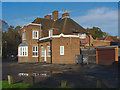
Eastern and Oriental restaurant
The side view of the Eastern and Oriental restaurant, formerly the Cricketers public house.
Image: © Alan Hunt
Taken: 5 Nov 2012
0.16 miles