IMAGES TAKEN NEAR TO
Linden Way, WOKING, GU22 9BS
Introduction
This page details the photographs taken nearby to Linden Way, GU22 9BS by members of the Geograph project.
The Geograph project started in 2005 with the aim of publishing, organising and preserving representative images for every square kilometre of Great Britain, Ireland and the Isle of Man.

There are currently over 7.5m images from over14,400 individuals and you can help contribute to the project by visiting https://www.geograph.org.uk
Image Map
Images are licensed for reuse under creativecommons.org/licenses/by-sa/2.0
Notes
- Clicking on the map will re-center to the selected point.
- The higher the marker number, the further away the image location is from the centre of the postcode.
Image Listing (7 Images Found)
Images are licensed for reuse under creativecommons.org/licenses/by-sa/2.0
Image
Details
Distance
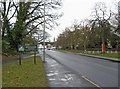
1
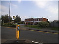
The Moorlands at the junction of Vicarage Road
Image: © David Howard
Taken: 7 Sep 2014
0.18 miles
2
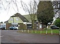
Old Woking & District Recreation Club, 33 Westfield Road
A sign outside indicates that the club's facilities include bowls, darts, pool, and snooker. A function room is also available. The club is CIU affiliated.
Image: © P L Chadwick
Taken: 12 Mar 2010
0.22 miles
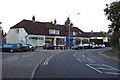
3
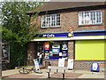
McColls Newsagent Westfield, Surrey
McColls Newsagent Westfield, Surrey, was formerly Forbouys, and before that a plant hire shop.
Image: © jason tutty
Taken: 19 Sep 2004
0.23 miles
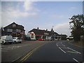
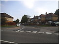
5
Westfield Road
A group of local shops are on the corner, in the distance.
Image: © P L Chadwick
Taken: 12 Mar 2010
0.24 miles