IMAGES TAKEN NEAR TO
Westfield Road, WOKING, GU22 9AX
Introduction
This page details the photographs taken nearby to Westfield Road, GU22 9AX by members of the Geograph project.
The Geograph project started in 2005 with the aim of publishing, organising and preserving representative images for every square kilometre of Great Britain, Ireland and the Isle of Man.

There are currently over 7.5m images from over14,400 individuals and you can help contribute to the project by visiting https://www.geograph.org.uk
Image Map
Images are licensed for reuse under creativecommons.org/licenses/by-sa/2.0
Notes
- Clicking on the map will re-center to the selected point.
- The higher the marker number, the further away the image location is from the centre of the postcode.
Image Listing (18 Images Found)
Images are licensed for reuse under creativecommons.org/licenses/by-sa/2.0
Image
Details
Distance
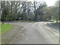
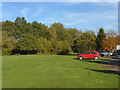
2
New Lane at the junction of Westfield Road
They are playing cricket on the left
Image: © David Howard
Taken: 7 Sep 2014
0.07 miles
3
Moor Lane at the junction of New Lane, Mayford
Image: © David Howard
Taken: 7 Sep 2014
0.11 miles
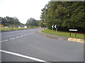
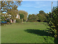
5
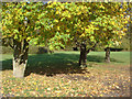
Westfield Common
The triangle of common land by Rose Bank Cottages
Image: © Alan Hunt
Taken: 5 Nov 2012
0.14 miles
6
New Lane
Looking north along New Lane with one of the cottages on Rose Bank in view.
Image: © Alan Hunt
Taken: 5 Nov 2012
0.16 miles
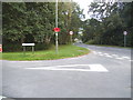
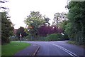
7
Westfield Common
Looking north across the triangle of common land in front of Rose Bank Cottages.
Image: © Alan Hunt
Taken: 5 Nov 2012
0.17 miles
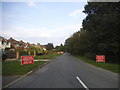
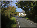
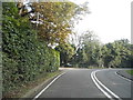
8
Beech Hill, near Mayford
Until the 1980s this was the A320 road between Woking and Guildford.
Image: © Ron Strutt
Taken: 29 Aug 2005
0.19 miles
10
Moor Lane
Looking across Moor Lane with the footpath to The Orchard beside the house on the far side.
Image: © Alan Hunt
Taken: 5 Nov 2012
0.19 miles