IMAGES TAKEN NEAR TO
Lock Lane, WOKING, GU22 8XL
Introduction
This page details the photographs taken nearby to Lock Lane, GU22 8XL by members of the Geograph project.
The Geograph project started in 2005 with the aim of publishing, organising and preserving representative images for every square kilometre of Great Britain, Ireland and the Isle of Man.

There are currently over 7.5m images from over14,400 individuals and you can help contribute to the project by visiting https://www.geograph.org.uk
Image Map
Images are licensed for reuse under creativecommons.org/licenses/by-sa/2.0
Notes
- Clicking on the map will re-center to the selected point.
- The higher the marker number, the further away the image location is from the centre of the postcode.
Image Listing (64 Images Found)
Images are licensed for reuse under creativecommons.org/licenses/by-sa/2.0
Image
Details
Distance
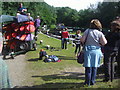
2
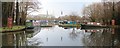
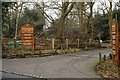
Pyrford Marina
Large leisure boating development on the west bank of the Wey Navigation, catering for cruisers and narrowboats. It contains pontoons, moorings, dry dock and a slipway.
http://www.tingdene-marinas.co.uk/Pyrford-marina.html
Image: © Colin Smith
Taken: 6 Mar 2011
0.09 miles
3
Looking from Lock Lane into the entrance of Pyrford Marina
Image: © Basher Eyre
Taken: 30 Oct 2020
0.09 miles
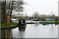
5
Entrance to Pyrford Marina
Seen from Lock Lane.
Image: © Peter Trimming
Taken: 2 Feb 2015
0.10 miles
6
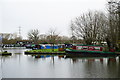
Pyrford Marina
Seen from the towpath of the River Wey Navigation.
Image: © Peter Trimming
Taken: 2 Feb 2015
0.10 miles
7
Pyrford Marina
Seen from the towpath of the River Wey Navigation.
Image: © Peter Trimming
Taken: 2 Feb 2015
0.10 miles
8
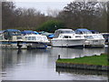
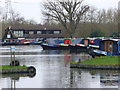
Cruisers at Pyrford Marina
Cabin cruisers moored at the mouth of Pyrford Marina, a large development on the Wey Navigation.
http://www.tingdene-marinas.co.uk/Pyrford-marina.html
Image: © Colin Smith
Taken: 6 Mar 2011
0.11 miles
10
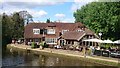
The Anchor, Pyrford Lock
The pub was built in 1721 for canal workers and boatmen. According to local historians it takes its name from 'anker' an 8.5 gallon measurement of beer.
The pub was rebuilt in 1934. Stables used to rest the horses and mules working the Navigation were demolished and replaced with a large patio and conservatory.
Image: © Mark Percy
Taken: 18 Apr 2017
0.15 miles