IMAGES TAKEN NEAR TO
Romans Way, WOKING, GU22 8TP
Introduction
This page details the photographs taken nearby to Romans Way, GU22 8TP by members of the Geograph project.
The Geograph project started in 2005 with the aim of publishing, organising and preserving representative images for every square kilometre of Great Britain, Ireland and the Isle of Man.

There are currently over 7.5m images from over14,400 individuals and you can help contribute to the project by visiting https://www.geograph.org.uk
Image Map
Images are licensed for reuse under creativecommons.org/licenses/by-sa/2.0
Notes
- Clicking on the map will re-center to the selected point.
- The higher the marker number, the further away the image location is from the centre of the postcode.
Image Listing (40 Images Found)
Images are licensed for reuse under creativecommons.org/licenses/by-sa/2.0
Image
Details
Distance
1
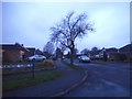
Peatmore Avenue on the corner of Peatmore Close, Pyrford
Image: © David Howard
Taken: 27 Dec 2015
0.06 miles
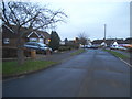
2

Path at the end of Peatmore Close, Pyrford
Image: © David Howard
Taken: 27 Dec 2015
0.10 miles
4

Access to garages at the end of Peatmore Close
Image: © David Howard
Taken: 27 Dec 2015
0.12 miles
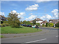
5

Ridgway estate
The football field at the end of Peatmore Close
Image: © Alan Hunt
Taken: 20 Aug 2012
0.12 miles

7
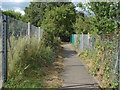
Footpath, Ridgway estate
The footpath from Coldharbour Road to the Ridgway estate that borders Pyrford Cricket Ground.
Image: © Alan Hunt
Taken: 20 Aug 2012
0.12 miles
8
Boltons Lane
The junction on Engliff Lane with Boltons Lane in West Byfleet's Ridgeway estate
Image: © Alan Hunt
Taken: 14 Aug 2012
0.12 miles

10
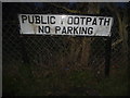
Old sign on Peatmore Close, Pyrford
This appears to have been made on a number plate machine as uses the same font. It's actually a driveway to the garages, which runs along the same route as the footpath, hence the sign, although it's impossible to park there without blocking the road entirely.
Image: © David Howard
Taken: 27 Dec 2015
0.13 miles