IMAGES TAKEN NEAR TO
Ridgway, WOKING, GU22 8PW
Introduction
This page details the photographs taken nearby to Ridgway, GU22 8PW by members of the Geograph project.
The Geograph project started in 2005 with the aim of publishing, organising and preserving representative images for every square kilometre of Great Britain, Ireland and the Isle of Man.

There are currently over 7.5m images from over14,400 individuals and you can help contribute to the project by visiting https://www.geograph.org.uk
Image Map
Images are licensed for reuse under creativecommons.org/licenses/by-sa/2.0
Notes
- Clicking on the map will re-center to the selected point.
- The higher the marker number, the further away the image location is from the centre of the postcode.
Image Listing (31 Images Found)
Images are licensed for reuse under creativecommons.org/licenses/by-sa/2.0
Image
Details
Distance


3
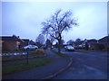
Peatmore Avenue on the corner of Peatmore Close, Pyrford
Image: © David Howard
Taken: 27 Dec 2015
0.14 miles

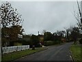
5
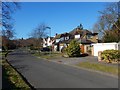
Ridgway - Hare Hill Close
Detached houses in Pyrford.
Image: © James Emmans
Taken: 25 Feb 2018
0.16 miles
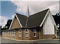
6

Church of the Good Shepherd, Pyrford: mid July 2015
Image: © Basher Eyre
Taken: 14 Jul 2015
0.16 miles
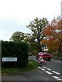
10
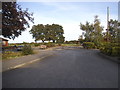
The entrance to Traditions golf course, Pyrford
Image: © David Howard
Taken: 5 Oct 2014
0.18 miles