IMAGES TAKEN NEAR TO
Pine Tree Hill, WOKING, GU22 8LY
Introduction
This page details the photographs taken nearby to Pine Tree Hill, GU22 8LY by members of the Geograph project.
The Geograph project started in 2005 with the aim of publishing, organising and preserving representative images for every square kilometre of Great Britain, Ireland and the Isle of Man.

There are currently over 7.5m images from over14,400 individuals and you can help contribute to the project by visiting https://www.geograph.org.uk
Image Map
Images are licensed for reuse under creativecommons.org/licenses/by-sa/2.0
Notes
- Clicking on the map will re-center to the selected point.
- The higher the marker number, the further away the image location is from the centre of the postcode.
Image Listing (10 Images Found)
Images are licensed for reuse under creativecommons.org/licenses/by-sa/2.0
Image
Details
Distance

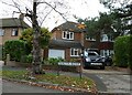
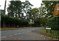
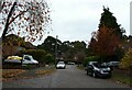
3
Looking from Bromcroft Drive into Old Woking Drive
Image: © Basher Eyre
Taken: 30 Oct 2020
0.09 miles
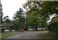
5
Looking from Forest Road into Old Woking Road
Image: © Basher Eyre
Taken: 30 Oct 2020
0.13 miles
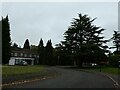
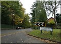
7
Looking from Hamilton Avenue into Donne Gardens
Image: © Basher Eyre
Taken: 30 Oct 2020
0.22 miles
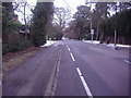
8
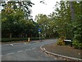
Looking from Lincoln Drive into Old Woking Road
Image: © Basher Eyre
Taken: 30 Oct 2020
0.23 miles
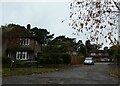
9
Looking north-northeast along Hamilton Avenue
Image: © Basher Eyre
Taken: 30 Oct 2020
0.24 miles