IMAGES TAKEN NEAR TO
Blackdown Close, WOKING, GU22 8LQ
Introduction
This page details the photographs taken nearby to Blackdown Close, GU22 8LQ by members of the Geograph project.
The Geograph project started in 2005 with the aim of publishing, organising and preserving representative images for every square kilometre of Great Britain, Ireland and the Isle of Man.

There are currently over 7.5m images from over14,400 individuals and you can help contribute to the project by visiting https://www.geograph.org.uk
Image Map
Images are licensed for reuse under creativecommons.org/licenses/by-sa/2.0
Notes
- Clicking on the map will re-center to the selected point.
- The higher the marker number, the further away the image location is from the centre of the postcode.
Image Listing (3 Images Found)
Images are licensed for reuse under creativecommons.org/licenses/by-sa/2.0
Image
Details
Distance
1
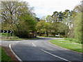
Pyrford Common Road
View along Pyrford Common Road towards its junction with the B382, Woking Road. The entrance to the Pyrford Common Recreation Ground can be seen on the left.
Image: © Alan Hunt
Taken: 1 May 2010
0.25 miles
2
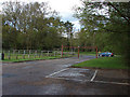
Pyrford Common car park
View looking out towards Pyrford Common Road through the entrance to the Pyrford Common car park.
Image: © Alan Hunt
Taken: 1 May 2010
0.25 miles
3
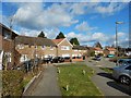
Maybury Estate - Beaufort Road
Post war estate outside Woking.
Image: © James Emmans
Taken: 11 Feb 2018
0.25 miles