IMAGES TAKEN NEAR TO
High Street, WOKING, GU22 8LB
Introduction
This page details the photographs taken nearby to High Street, GU22 8LB by members of the Geograph project.
The Geograph project started in 2005 with the aim of publishing, organising and preserving representative images for every square kilometre of Great Britain, Ireland and the Isle of Man.

There are currently over 7.5m images from over14,400 individuals and you can help contribute to the project by visiting https://www.geograph.org.uk
Image Map
Images are licensed for reuse under creativecommons.org/licenses/by-sa/2.0
Notes
- Clicking on the map will re-center to the selected point.
- The higher the marker number, the further away the image location is from the centre of the postcode.
Image Listing (146 Images Found)
Images are licensed for reuse under creativecommons.org/licenses/by-sa/2.0
Image
Details
Distance
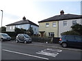
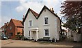
1
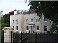
Old Woking Grange
Large and imposing old Georgian building at the east end of Old Woking High Street. It is now a nursing home.
Image: © Colin Smith
Taken: 30 Sep 2007
0.01 miles
5
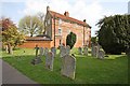
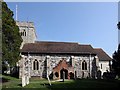
St Peter, Old Woking, Surrey - Churchyard
Image: © John Salmon
Taken: 21 Apr 2009
0.06 miles
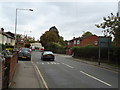
6
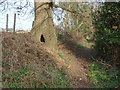
Footpath, Old Woking
The footpath that runs from the High Street to Carters Lane. St Peters graveyard is over the hedge on the right. An unusual gnome hole at the base of the tree.
Image: © Alan Hunt
Taken: 15 Mar 2012
0.07 miles
7
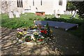
St Peter, Old Woking, Surrey - Memorial garden
Image: © John Salmon
Taken: 21 Apr 2009
0.07 miles
9
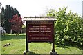
St Peter, Old Woking, Surrey - Notice board
Image: © John Salmon
Taken: 21 Apr 2009
0.08 miles