IMAGES TAKEN NEAR TO
Lydger Close, WOKING, GU22 8JW
Introduction
This page details the photographs taken nearby to Lydger Close, GU22 8JW by members of the Geograph project.
The Geograph project started in 2005 with the aim of publishing, organising and preserving representative images for every square kilometre of Great Britain, Ireland and the Isle of Man.

There are currently over 7.5m images from over14,400 individuals and you can help contribute to the project by visiting https://www.geograph.org.uk
Image Map
Images are licensed for reuse under creativecommons.org/licenses/by-sa/2.0
Notes
- Clicking on the map will re-center to the selected point.
- The higher the marker number, the further away the image location is from the centre of the postcode.
Image Listing (18 Images Found)
Images are licensed for reuse under creativecommons.org/licenses/by-sa/2.0
Image
Details
Distance
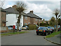
1
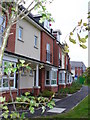
Palace Way, Old Woking
Modern terraced housing where a factory stood until 1-2 years ago. The street takes its name from Woking Palace which was a nearby Tudor residence.
Image: © Colin Smith
Taken: 30 Sep 2007
0.06 miles
2
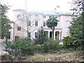
Hoe Bridge School
This school used to be Hoe Place which was built using stones from nearby Woking Palace. Its first name, Hoe Place School (say it quickly!), was soon changed to its current one!
Image: © Colin Smith
Taken: 1 Mar 2009
0.11 miles
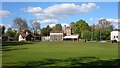
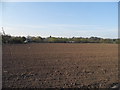
4
Junior football, Old Woking
On St Peter's Recreation Ground.
Image: © Robin Webster
Taken: 18 Mar 2012
0.13 miles
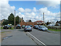
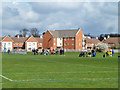
7
St Peter's Road
By the junction with Corrie Road.
Image: © Robin Webster
Taken: 18 Mar 2012
0.17 miles
8
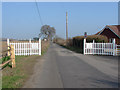
Carters Lane
Very long and as straight as an arrow this access road/bridleway disappears into the distance towards Park Farm.
Image: © Alan Hunt
Taken: 15 Mar 2012
0.18 miles
9
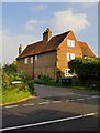
The Old House, Old Woking Road
At the corner of Carters Lane. From the road I wasn't able to see any architectural details that would help put a date on the building. But what is quite clear is that much of the brickwork is made up of small bricks, of a size used in the 17th century (and earlier).
Image: © Stefan Czapski
Taken: 24 Sep 2013
0.18 miles
10
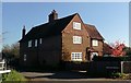
The Old House - Old Woking Road
House is at the junction with Carters Lane.
Image: © James Emmans
Taken: 19 Nov 2018
0.18 miles