IMAGES TAKEN NEAR TO
Latimer Close, WOKING, GU22 8HD
Introduction
This page details the photographs taken nearby to Latimer Close, GU22 8HD by members of the Geograph project.
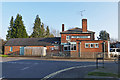
The Geograph project started in 2005 with the aim of publishing, organising and preserving representative images for every square kilometre of Great Britain, Ireland and the Isle of Man.

There are currently over 7.5m images from over14,400 individuals and you can help contribute to the project by visiting https://www.geograph.org.uk
Image Map
Images are licensed for reuse under creativecommons.org/licenses/by-sa/2.0
Notes
- Clicking on the map will re-center to the selected point.
- The higher the marker number, the further away the image location is from the centre of the postcode.
Image Listing (89 Images Found)
Images are licensed for reuse under creativecommons.org/licenses/by-sa/2.0
Image
Details
Distance
1
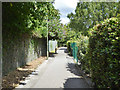
Path eastwards from Maybury Hill beside railway
It links to Pollard, Beta and Alpha Roads.
Image: © Robin Webster
Taken: 2 Aug 2020
0.02 miles
2
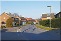
Princess Road, Woking
Princess Road in the Maybury Estate.
Image: © Alan Hunt
Taken: 17 Mar 2016
0.05 miles
3
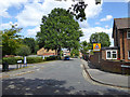
Alpha Road, Maybury
Alpha Road, as a name, is one of the older roads in this fringe of Maybury, but this continuation round the corner is post-war.
Image: © Robin Webster
Taken: 2 Aug 2020
0.05 miles
4
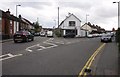
One-way system, east Woking
This will change when the Sheerwater Access Improvement Scheme http://www.woking.gov.uk/business/sheerwateraccessscheme is completed; Eve Road, on the right, will be closed to through traffic to create a residential cul-de-sac. On the left is Arnold Road; not sure what's happening to that. On the corner between the two is a furniture shop.
Image: © Derek Harper
Taken: 10 May 2013
0.07 miles
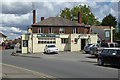
5
The Princess pub, Woking
The Princess public house on Princess Road viewed brom Beta Road.
Image: © Alan Hunt
Taken: 17 Mar 2016
0.08 miles
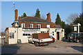
6
The Princess, Princess Road, Maybury, Woking
A pub that appears to have changed sex - on an 1870s survey it was called the Prince of Wales. Although not named on maps thereafter, it was later the Princess of Wales (unless the OS got it wrong in the first place). H.G. Wells in 'War of the Worlds', written in 1895, does not refer to either name, but has a 'Spotted Dog' not far from his Narrator's house where he hired a dog cart for his household evacuation. It has been surmised that he had this pub in mind.
Image: © Robin Webster
Taken: 2 Aug 2020
0.09 miles
7
The Princess, Maybury
The Princess public house on Princess Road in the Maybury area of Woking.
Image: © Alan Hunt
Taken: 17 Mar 2016
0.09 miles
8
Houses, Monument Road, Maybury, Woking
Variously referred to as Oriental Place, Oriental Terrace and Oriental Parade by maps and other accounts. H.G. Wells in 'War of the Worlds' written in 1895 calls it 'The pretty little row of gables that was called Oriental Terrace'.
Image: © Robin Webster
Taken: 2 Aug 2020
0.10 miles
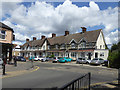
9
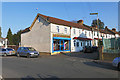
Frailey Hill, Woking
The Princess dress shop at the junction of Frailey Hill with Princess Road in the Maybury area of Woking.
Image: © Alan Hunt
Taken: 17 Mar 2016
0.11 miles
10
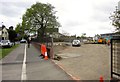
Sheerwater Access Improvement Scheme
See Image Here the line of the new road is being prepared across a former car park beside Woking Business Park (right).
Image: © Derek Harper
Taken: 10 May 2013
0.11 miles