IMAGES TAKEN NEAR TO
Maybury Hill, WOKING, GU22 8AF
Introduction
This page details the photographs taken nearby to Maybury Hill, GU22 8AF by members of the Geograph project.
The Geograph project started in 2005 with the aim of publishing, organising and preserving representative images for every square kilometre of Great Britain, Ireland and the Isle of Man.

There are currently over 7.5m images from over14,400 individuals and you can help contribute to the project by visiting https://www.geograph.org.uk
Image Map
Images are licensed for reuse under creativecommons.org/licenses/by-sa/2.0
Notes
- Clicking on the map will re-center to the selected point.
- The higher the marker number, the further away the image location is from the centre of the postcode.
Image Listing (57 Images Found)
Images are licensed for reuse under creativecommons.org/licenses/by-sa/2.0
Image
Details
Distance
1
Maybury Rough, apartments beside Maybury Hill
Image: © Roger Templeman
Taken: 17 Feb 2015
0.03 miles
2
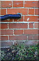
'Pookshill', Pembroke Road
There is an OS benchmark Image below the black pipe through the wall right of the black downpipe
Image: © Roger Templeman
Taken: 17 Feb 2015
0.08 miles
3
Benchmark on 'Pookshill'
Ordnance Survey cut mark benchmark described on the Bench Mark Database at http://www.bench-marks.org.uk/bm64361
Image: © Roger Templeman
Taken: 17 Feb 2015
0.08 miles
4
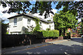
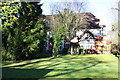
House, corner of Maybury Hill and Pembroke Road
Victorian Maybury Hill, the road and roads off it, mostly had a few well spaced large houses. This, being semi-detached, was possibly one of the humbler ones. The area was where the Narrator in H.G. Wells's 'War of the Worlds' lived. It is probably where H.G. would have liked to have lived. He actually wrote the book whilst living down the hill in a fairly humble rented house by the railway on Maybury Road.
Image: © Robin Webster
Taken: 2 Aug 2020
0.09 miles
5
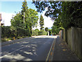
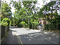
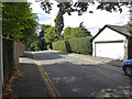
Pembroke Road, Woking
Looking east, towards its junction with Maybury Hill.
Image: © Robin Webster
Taken: 2 Aug 2020
0.10 miles
6
The Pinnacles, Maybury
The newly built Pinnacles development based on Convent Road.
Image: © Alan Hunt
Taken: 1 Oct 2011
0.10 miles
7
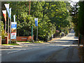
Pembroke Road, Woking
Looking west, away from its junction with Maybury Hill.
Image: © Robin Webster
Taken: 2 Aug 2020
0.11 miles
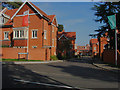
8
Maybury Hill, Woking
A view along Maybury Hill with the recently built Pinnacles development on the right.
Image: © Alan Hunt
Taken: 1 Oct 2011
0.11 miles