IMAGES TAKEN NEAR TO
York Road, WOKING, GU22 7XN
Introduction
This page details the photographs taken nearby to York Road, GU22 7XN by members of the Geograph project.
The Geograph project started in 2005 with the aim of publishing, organising and preserving representative images for every square kilometre of Great Britain, Ireland and the Isle of Man.

There are currently over 7.5m images from over14,400 individuals and you can help contribute to the project by visiting https://www.geograph.org.uk
Image Map
Images are licensed for reuse under creativecommons.org/licenses/by-sa/2.0
Notes
- Clicking on the map will re-center to the selected point.
- The higher the marker number, the further away the image location is from the centre of the postcode.
Image Listing (91 Images Found)
Images are licensed for reuse under creativecommons.org/licenses/by-sa/2.0
Image
Details
Distance
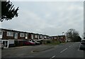
1
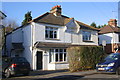
Semi-detached houses on York Road
#69 and #67 in this image
Image: © Roger Templeman
Taken: 17 Feb 2015
0.04 miles
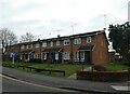
4
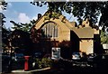
St Mary of Bethany, Woking
Grade 2 listed building erected in 1907.
Image: © Michael FORD
Taken: Unknown
0.05 miles
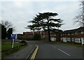
9
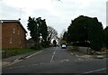
Looking from Mount Hermon Road into Brooklyn Road
Image: © Basher Eyre
Taken: 21 Dec 2021
0.07 miles
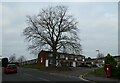
10
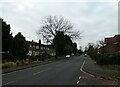
Looking from Brooklyn Road into Mount Hermon Road
Image: © Basher Eyre
Taken: 21 Dec 2021
0.07 miles