IMAGES TAKEN NEAR TO
White Rose Lane, WOKING, GU22 7LP
Introduction
This page details the photographs taken nearby to White Rose Lane, GU22 7LP by members of the Geograph project.
The Geograph project started in 2005 with the aim of publishing, organising and preserving representative images for every square kilometre of Great Britain, Ireland and the Isle of Man.

There are currently over 7.5m images from over14,400 individuals and you can help contribute to the project by visiting https://www.geograph.org.uk
Image Map
Images are licensed for reuse under creativecommons.org/licenses/by-sa/2.0
Notes
- Clicking on the map will re-center to the selected point.
- The higher the marker number, the further away the image location is from the centre of the postcode.
Image Listing (13 Images Found)
Images are licensed for reuse under creativecommons.org/licenses/by-sa/2.0
Image
Details
Distance
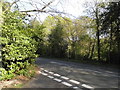
3
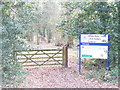
White Rose Lane Local Nature Reserve
Entry into the reserve from White Rose Lane, Woking. The reserve is on the banks of the River Hoe, a Wey tributary.
Image: © Colin Smith
Taken: 1 Mar 2009
0.08 miles
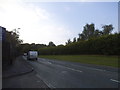
4
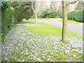
Knowl Hill
On the Hockering Estate, an exclusive area of upmarket residences, detached and hidden behind hedges. The wide grassy verge of the road here is carpeted with flowering crocuses.
Image: © Colin Smith
Taken: 1 Mar 2009
0.09 miles
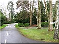
5
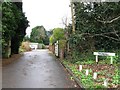
White Rose Lane at the junction of Clear Down
Image: © David Howard
Taken: 20 Apr 2015
0.13 miles
7
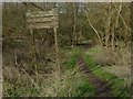
The White Rose Lane nature reserve
The sign at the entrance to this small local nature reserve from the footbridge across the Hoe Stream.
Image: © Alan Hunt
Taken: 14 Mar 2012
0.16 miles
9
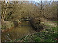
The Hoe Stream
A footbridge across the stream giving access to the White Rose Lane local nature reserve.
Image: © Alan Hunt
Taken: 14 Mar 2012
0.17 miles
10
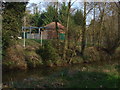
The Hoe Stream
A view across the Hoe Stream with what is marked on the maps as a station, but definitely not related to the railways.
Image: © Alan Hunt
Taken: 14 Mar 2012
0.18 miles