IMAGES TAKEN NEAR TO
Rosewood, WOKING, GU22 7LE
Introduction
This page details the photographs taken nearby to Rosewood, GU22 7LE by members of the Geograph project.
The Geograph project started in 2005 with the aim of publishing, organising and preserving representative images for every square kilometre of Great Britain, Ireland and the Isle of Man.

There are currently over 7.5m images from over14,400 individuals and you can help contribute to the project by visiting https://www.geograph.org.uk
Image Map
Images are licensed for reuse under creativecommons.org/licenses/by-sa/2.0
Notes
- Clicking on the map will re-center to the selected point.
- The higher the marker number, the further away the image location is from the centre of the postcode.
Image Listing (53 Images Found)
Images are licensed for reuse under creativecommons.org/licenses/by-sa/2.0
Image
Details
Distance
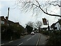
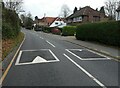
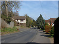
1
White Rose Lane
The road that runs from near Woking station to Monument Hill.
Image: © Alan Hunt
Taken: 14 Mar 2012
0.04 miles
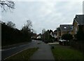
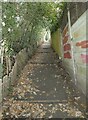
5
Looking from White Rose Lane into Rose Wood
Image: © Basher Eyre
Taken: 21 Dec 2021
0.04 miles
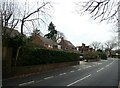
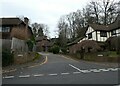
6
White Rose Lane
The junction of White Rose Lane with Rosewood, an short cul-de-sac. Just beyond this point White Rose Lane borders the Hockerings estate, one of the most expensive areas of Woking.
Image: © Alan Hunt
Taken: 14 Mar 2012
0.04 miles