IMAGES TAKEN NEAR TO
St. Pauls Road, WOKING, GU22 7DZ
Introduction
This page details the photographs taken nearby to St. Pauls Road, GU22 7DZ by members of the Geograph project.
The Geograph project started in 2005 with the aim of publishing, organising and preserving representative images for every square kilometre of Great Britain, Ireland and the Isle of Man.

There are currently over 7.5m images from over14,400 individuals and you can help contribute to the project by visiting https://www.geograph.org.uk
Image Map
Images are licensed for reuse under creativecommons.org/licenses/by-sa/2.0
Notes
- Clicking on the map will re-center to the selected point.
- The higher the marker number, the further away the image location is from the centre of the postcode.
Image Listing (40 Images Found)
Images are licensed for reuse under creativecommons.org/licenses/by-sa/2.0
Image
Details
Distance
1
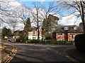
Horsell
Houses on Onslow Crescent and Shaftesbury Avenue.
Image: © James Emmans
Taken: 11 Feb 2018
0.08 miles
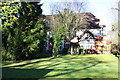
2
George Bernard Shaw's house
The writer George Bernard Shaw lived at Maybury Knowle, The Ridge, 1901-03. His house has been replaced by this block of flats [source - Walk Around Historic Woking, Marion Field, 2005].
Image: © David Griffiths
Taken: 1 Jul 2005
0.12 miles
3
Oriental Road, Woking
This largely residential road runs from Maybury Hill to the Guildford Road near the station.
Image: © Alan Hunt
Taken: 20 May 2015
0.15 miles
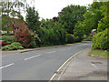
6
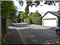
Pembroke Road, Woking
Looking west, away from its junction with Maybury Hill.
Image: © Robin Webster
Taken: 2 Aug 2020
0.17 miles
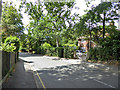
7
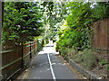
Path from Pembroke Road to Oriental Road, Maybury, Woking
Not dedicated to the public, according to a sign, it appears to belong to the church. Nevertheless, the public seem to be expected to use it.
Image: © Robin Webster
Taken: 2 Aug 2020
0.17 miles
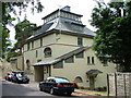
8
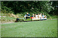
Miniature railway, Southern Railway Children's Home, 1969
The exact location within the grounds is a bit of a guess, but it went round a field. The site is now redeveloped.
Image: © Robin Webster
Taken: Unknown
0.17 miles
9
Maybury Rough, apartments beside Maybury Hill
Image: © Roger Templeman
Taken: 17 Feb 2015
0.18 miles
10
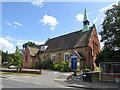
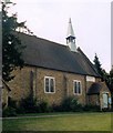
St. Paul's Church, Maybury
Mapping suggests late Victorian for this older front part - not there 1870s, there 1890s.
Image: © Robin Webster
Taken: 2 Aug 2020
0.19 miles