IMAGES TAKEN NEAR TO
Lytton Road, WOKING, GU22 7BH
Introduction
This page details the photographs taken nearby to Lytton Road, GU22 7BH by members of the Geograph project.
The Geograph project started in 2005 with the aim of publishing, organising and preserving representative images for every square kilometre of Great Britain, Ireland and the Isle of Man.

There are currently over 7.5m images from over14,400 individuals and you can help contribute to the project by visiting https://www.geograph.org.uk
Image Map
Images are licensed for reuse under creativecommons.org/licenses/by-sa/2.0
Notes
- Clicking on the map will re-center to the selected point.
- The higher the marker number, the further away the image location is from the centre of the postcode.
Image Listing (72 Images Found)
Images are licensed for reuse under creativecommons.org/licenses/by-sa/2.0
Image
Details
Distance
1
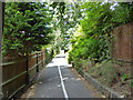
Oriental Road, Woking
This largely residential road runs from Maybury Hill to the Guildford Road near the station.
Image: © Alan Hunt
Taken: 20 May 2015
0.03 miles
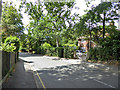
3
Path from Pembroke Road to Oriental Road, Maybury, Woking
Not dedicated to the public, according to a sign, it appears to belong to the church. Nevertheless, the public seem to be expected to use it.
Image: © Robin Webster
Taken: 2 Aug 2020
0.06 miles
5

Shah Jahan Mosque: early September 2015
It is a long time since I submitted a mosque. This one has quite a history https://en.wikipedia.org/wiki/Shah_Jahan_Mosque,_Woking
Image: © Basher Eyre
Taken: 7 Sep 2015
0.07 miles
6
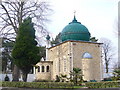
Shah Jehan Mosque
Woking has Britain's first purpose-built mosque. It was built in 1889 in the grounds of Dr Leitner's Oriental Institute for his Muslim students. The mosque was funded by Bhopal's ruler, Begum Shah Jehan. Today, the large local Pakistani community use the building.
http://www.shahjahanmosque.org.uk/index.html
Image: © Colin Smith
Taken: 1 Mar 2009
0.07 miles
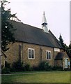
7
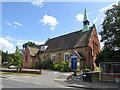
St. Paul's Church, Maybury
Mapping suggests late Victorian for this older front part - not there 1870s, there 1890s.
Image: © Robin Webster
Taken: 2 Aug 2020
0.07 miles

9
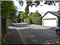
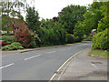
Pembroke Road, Woking
Looking west, away from its junction with Maybury Hill.
Image: © Robin Webster
Taken: 2 Aug 2020
0.08 miles
