IMAGES TAKEN NEAR TO
Kemishford, WOKING, GU22 0RL
Introduction
This page details the photographs taken nearby to Kemishford, GU22 0RL by members of the Geograph project.
The Geograph project started in 2005 with the aim of publishing, organising and preserving representative images for every square kilometre of Great Britain, Ireland and the Isle of Man.

There are currently over 7.5m images from over14,400 individuals and you can help contribute to the project by visiting https://www.geograph.org.uk
Image Map
Images are licensed for reuse under creativecommons.org/licenses/by-sa/2.0
Notes
- Clicking on the map will re-center to the selected point.
- The higher the marker number, the further away the image location is from the centre of the postcode.
Image Listing (20 Images Found)
Images are licensed for reuse under creativecommons.org/licenses/by-sa/2.0
Image
Details
Distance
1
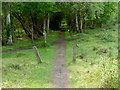
Smarts Heath
The main track running through the more wooded section on the southern boundary. it exits onto Smarts Heath Lane.
Image: © Alan Hunt
Taken: 5 Jun 2010
0.05 miles
2
Smart's Heath
Now owned by Woking Borough Council
Image: © Ron Strutt
Taken: 29 Aug 2005
0.05 miles
5
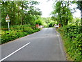
Approaching Kemishford Bridge
Hoe Stream is below the bridge.
Image: © Shazz
Taken: 27 Jul 2014
0.10 miles
6
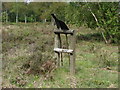
Smarts Heath
Fire beaters by the main path.
Image: © Alan Hunt
Taken: 5 Jun 2010
0.10 miles
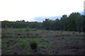
7
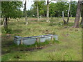
Smarts Heath
Water trough for the cows that have been introduced onto this area of heathland.
Image: © Alan Hunt
Taken: 5 Jun 2010
0.11 miles
8
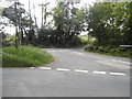
Prey Heath Road at the junction of Smart's Heath Lane
Image: © David Howard
Taken: 7 Sep 2014
0.12 miles
9
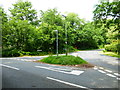
Road junction just south of Kemishford Bridge
Image: © Shazz
Taken: 27 Jul 2014
0.13 miles
10
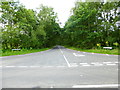
Looking into Smart's Heath Lane from the north
Image: © Shazz
Taken: 27 Jul 2014
0.21 miles