IMAGES TAKEN NEAR TO
Saunders Copse, WOKING, GU22 0NS
Introduction
This page details the photographs taken nearby to Saunders Copse, GU22 0NS by members of the Geograph project.
The Geograph project started in 2005 with the aim of publishing, organising and preserving representative images for every square kilometre of Great Britain, Ireland and the Isle of Man.

There are currently over 7.5m images from over14,400 individuals and you can help contribute to the project by visiting https://www.geograph.org.uk
Image Map
Images are licensed for reuse under creativecommons.org/licenses/by-sa/2.0
Notes
- Clicking on the map will re-center to the selected point.
- The higher the marker number, the further away the image location is from the centre of the postcode.
Image Listing (17 Images Found)
Images are licensed for reuse under creativecommons.org/licenses/by-sa/2.0
Image
Details
Distance
1
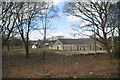
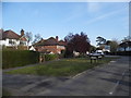
Mayford Village Hall
The hall was expanded, due to the considerable fund raising efforts of the community, in particular Ron Boarer MBE.
Image: © Graham Horn
Taken: 8 Nov 2009
0.08 miles
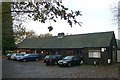
2
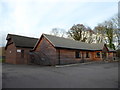
Mayford Village Hall: early February 2017
Image: © Basher Eyre
Taken: 7 Feb 2017
0.08 miles
3
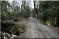
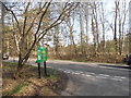
Road junction, Mayford
The junction of Saunders Lane and Goose Lane, Mayford.
Image: © Paul E Smith
Taken: 14 Mar 2010
0.10 miles
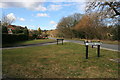
4

Mayford play area
The play area next to Mayford recreation ground.
Image: © Paul E Smith
Taken: 14 Mar 2010
0.12 miles
5
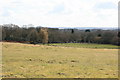
Mayford recreation ground
Looking down on Mayford recreation ground from the direction of Hook Heath.
Image: © Paul E Smith
Taken: 14 Mar 2010
0.13 miles
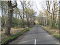
9
Smart's Heath Road at the junction of Goose Lane
Image: © David Howard
Taken: 20 Apr 2015
0.19 miles