IMAGES TAKEN NEAR TO
Cedar Road, WOKING, GU22 0JJ
Introduction
This page details the photographs taken nearby to Cedar Road, GU22 0JJ by members of the Geograph project.
The Geograph project started in 2005 with the aim of publishing, organising and preserving representative images for every square kilometre of Great Britain, Ireland and the Isle of Man.

There are currently over 7.5m images from over14,400 individuals and you can help contribute to the project by visiting https://www.geograph.org.uk
Image Map
Images are licensed for reuse under creativecommons.org/licenses/by-sa/2.0
Notes
- Clicking on the map will re-center to the selected point.
- The higher the marker number, the further away the image location is from the centre of the postcode.
Image Listing (15 Images Found)
Images are licensed for reuse under creativecommons.org/licenses/by-sa/2.0
Image
Details
Distance
4
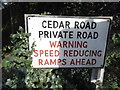
Sign for Cedar Road, Hook Heath
The design is 1950s or so, I have never come across humps that early but they are private roads who can do what they like.
Image: © David Howard
Taken: 20 Apr 2015
0.08 miles
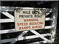
7
Junction of Mile Path, Holly Bank Road and Cedar Road
Image: © Basher Eyre
Taken: 7 Feb 2017
0.09 miles
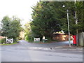
9
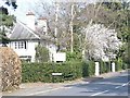
Hook Heath
An area in south-west Woking which teems with large upmarket houses, mostly hidden behind tall hedges. This house is now a residential home.
Image: © Colin Smith
Taken: 21 Mar 2009
0.13 miles