IMAGES TAKEN NEAR TO
Hawthorn Road, WOKING, GU22 0BG
Introduction
This page details the photographs taken nearby to Hawthorn Road, GU22 0BG by members of the Geograph project.
The Geograph project started in 2005 with the aim of publishing, organising and preserving representative images for every square kilometre of Great Britain, Ireland and the Isle of Man.

There are currently over 7.5m images from over14,400 individuals and you can help contribute to the project by visiting https://www.geograph.org.uk
Image Map
Images are licensed for reuse under creativecommons.org/licenses/by-sa/2.0
Notes
- Clicking on the map will re-center to the selected point.
- The higher the marker number, the further away the image location is from the centre of the postcode.
Image Listing (35 Images Found)
Images are licensed for reuse under creativecommons.org/licenses/by-sa/2.0
Image
Details
Distance

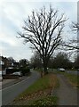
2
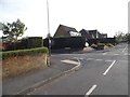
Egley Road at the junction of Acacia Avenue
Image: © David Howard
Taken: 20 Apr 2015
0.11 miles
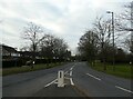
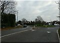
3
Roundabout at the junction of Guildford and Eglwy Roads with Wych Hill Lane (B)
Image: © Basher Eyre
Taken: 21 Dec 2021
0.14 miles
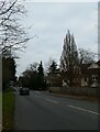
4
Looking south-southwest along Egley Road
Image: © Basher Eyre
Taken: 21 Dec 2021
0.14 miles
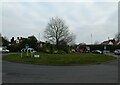
5

Grass triangle between Wych Hill Lane, Guildford Lane and Egley Road
Image: © Basher Eyre
Taken: 21 Dec 2021
0.14 miles
6
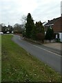
Approaching the junction of Turnoak Lane and Wych Hill Lane
Image: © Basher Eyre
Taken: 21 Dec 2021
0.15 miles
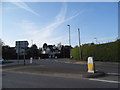
8
Roundabout at the junction of Guildford and Eglwy Roads with Wych Hill Lane (A)
Image: © Basher Eyre
Taken: 21 Dec 2021
0.16 miles
10
Looking back towards the junction of Wych Hill Lane with West Hill Road
Image: © Basher Eyre
Taken: 21 Dec 2021
0.17 miles