IMAGES TAKEN NEAR TO
Hawthorn Road, WOKING, GU22 0BD
Introduction
This page details the photographs taken nearby to Hawthorn Road, GU22 0BD by members of the Geograph project.
The Geograph project started in 2005 with the aim of publishing, organising and preserving representative images for every square kilometre of Great Britain, Ireland and the Isle of Man.

There are currently over 7.5m images from over14,400 individuals and you can help contribute to the project by visiting https://www.geograph.org.uk
Image Map
Images are licensed for reuse under creativecommons.org/licenses/by-sa/2.0
Notes
- Clicking on the map will re-center to the selected point.
- The higher the marker number, the further away the image location is from the centre of the postcode.
Image Listing (12 Images Found)
Images are licensed for reuse under creativecommons.org/licenses/by-sa/2.0
Image
Details
Distance


4
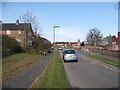
Egley Road at the junction of Acacia Avenue
Image: © David Howard
Taken: 20 Apr 2015
0.10 miles

6
Barnsbury Farm Estate - Almond Avenue
Part of the 1950's housing developments of Woking.
http://wokinghistory.org/onewebmedia/170630.pdf
Image: © James Emmans
Taken: 19 Nov 2018
0.15 miles
8
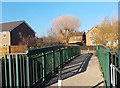
Foot Bridge over Hoe Stream
Hoe Stream becomes The Bourne downstream then flows into Abbey Stream part of the River Wey.
Image: © James Emmans
Taken: 19 Nov 2018
0.20 miles