IMAGES TAKEN NEAR TO
Egley Road, WOKING, GU22 0AF
Introduction
This page details the photographs taken nearby to Egley Road, GU22 0AF by members of the Geograph project.
The Geograph project started in 2005 with the aim of publishing, organising and preserving representative images for every square kilometre of Great Britain, Ireland and the Isle of Man.

There are currently over 7.5m images from over14,400 individuals and you can help contribute to the project by visiting https://www.geograph.org.uk
Image Map
Images are licensed for reuse under creativecommons.org/licenses/by-sa/2.0
Notes
- Clicking on the map will re-center to the selected point.
- The higher the marker number, the further away the image location is from the centre of the postcode.
Image Listing (20 Images Found)
Images are licensed for reuse under creativecommons.org/licenses/by-sa/2.0
Image
Details
Distance
1

Woking Garden Centre
Although now part of a chain of garden centres this one can trace its past back to 1810 when the business was first started by George Jackman on a site very close to the present one. Known as Jackman's Nursery, it remained in the family until 1967 and kept its name until 1996. The second George Jackman (1837-1887) was an expert at hybridising Clematis, winning an RHS First Class certificate for Clematis Jackmanii.
Image: © Richard Rogerson
Taken: 13 Oct 2012
0.07 miles
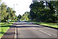
4
The Hoe Valley
A view of the fields between the Hoe stream and the A320 in Mayford.
Image: © Alan Hunt
Taken: 7 Aug 2011
0.10 miles
5
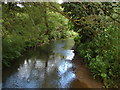
Hoe Stream, Woking
A view of the Hoe Stream from the footbridge near Drakes Way.
Image: © Alan Hunt
Taken: 7 Aug 2011
0.15 miles
6
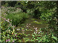
The Hoe Stream
Himalayan Balsam on the banks of the Hoe Steam. Unfortunately this invasive weed has been allowed to grow unchecked in the Mayford Meadows and will prove difficult to bring under control.
Image: © Alan Hunt
Taken: 7 Aug 2011
0.15 miles
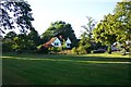
7
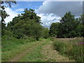
Mayford Meadows
The meadows are part of the Hoe Valley open access area
Image: © Alan Hunt
Taken: 7 Aug 2011
0.15 miles
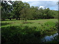
8
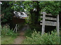
Mayford Meadows
The footpath bridge across the Hoe Stream with the houses on Drakes Way in the background
Image: © Alan Hunt
Taken: 7 Aug 2011
0.15 miles
9
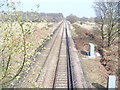
Next Stop, Woking.
Looking north towards Woking from Hook Hill Lane railway bridge. This is the Guildford-Woking line.
Image: © Colin Smith
Taken: 21 Mar 2009
0.16 miles
10

Mayford - Seahorse
This popular garden centre has an aquarium - another string to its commercial bow.
Image: © Colin Smith
Taken: 24 Mar 2019
0.17 miles