IMAGES TAKEN NEAR TO
Hermitage Bridge, WOKING, GU21 8XP
Introduction
This page details the photographs taken nearby to Hermitage Bridge, GU21 8XP by members of the Geograph project.
The Geograph project started in 2005 with the aim of publishing, organising and preserving representative images for every square kilometre of Great Britain, Ireland and the Isle of Man.

There are currently over 7.5m images from over14,400 individuals and you can help contribute to the project by visiting https://www.geograph.org.uk
Image Map
Images are licensed for reuse under creativecommons.org/licenses/by-sa/2.0
Notes
- Clicking on the map will re-center to the selected point.
- The higher the marker number, the further away the image location is from the centre of the postcode.
Image Listing (83 Images Found)
Images are licensed for reuse under creativecommons.org/licenses/by-sa/2.0
Image
Details
Distance
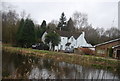
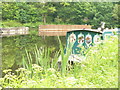
3
Houses by the Basingstoke Canal
Houses overlooking the Hermitage Bridge basin near Brookwood.
Image: © Alan Hunt
Taken: 19 Sep 2015
0.02 miles
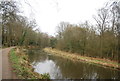
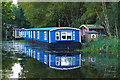
4
Turning Basin by Hermitage Bridge
Barges moored at this wider section of the Basingstoke Canal on the western edge of Woking.
Image: © Colin Smith
Taken: 27 May 2008
0.02 miles
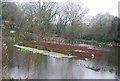
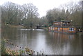
5
Houseboats on the Basingstoke Canal
Houseboats in the Hermitage Bridge basin in Brookwood.
Image: © Alan Hunt
Taken: 19 Sep 2015
0.02 miles
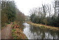
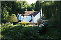
8
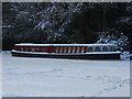
Basingstoke canal
Ice locked canal boat near the Hermitage Bridge
Image: © Alan Hunt
Taken: 9 Jan 2010
0.04 miles
9
Basingstoke Canal
Barges locked in the ice near the Hermitage Bridge.
Image: © Alan Hunt
Taken: 9 Jan 2010
0.04 miles