IMAGES TAKEN NEAR TO
St. Johns Mews, WOKING, GU21 7XN
Introduction
This page details the photographs taken nearby to St. Johns Mews, GU21 7XN by members of the Geograph project.
The Geograph project started in 2005 with the aim of publishing, organising and preserving representative images for every square kilometre of Great Britain, Ireland and the Isle of Man.

There are currently over 7.5m images from over14,400 individuals and you can help contribute to the project by visiting https://www.geograph.org.uk
Image Map
Images are licensed for reuse under creativecommons.org/licenses/by-sa/2.0
Notes
- Clicking on the map will re-center to the selected point.
- The higher the marker number, the further away the image location is from the centre of the postcode.
Image Listing (135 Images Found)
Images are licensed for reuse under creativecommons.org/licenses/by-sa/2.0
Image
Details
Distance
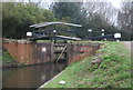
1
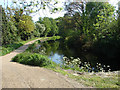
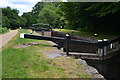
Basingstoke Canal
View east from lock 11. The towpath has recently been upgraded and is now a cycle way
Image: © Alan Hunt
Taken: 15 May 2010
0.02 miles
2
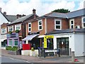
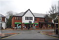
Woking - St John's Village
Close to the post office are Penny Blacks shop and the Old post Office Mews.
Image: © Colin Smith
Taken: 7 Aug 2016
0.03 miles
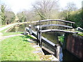
3
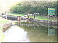
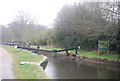
St John's Flight
Lock 11 at the top of the flight is adjacent to Kiln Bridge in St John's, a suburb of Woking.
Image: © Colin Smith
Taken: 21 Mar 2009
0.03 miles
10
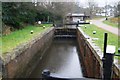
Basingstoke Canal, St John's
Looking along the canal from the top lock of the St John's Flight.
Image: © Colin Smith
Taken: 21 Mar 2009
0.04 miles