IMAGES TAKEN NEAR TO
St. Johns Lye, WOKING, GU21 7RS
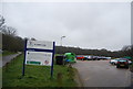
Introduction
This page details the photographs taken nearby to St. Johns Lye, GU21 7RS by members of the Geograph project.
The Geograph project started in 2005 with the aim of publishing, organising and preserving representative images for every square kilometre of Great Britain, Ireland and the Isle of Man.

There are currently over 7.5m images from over14,400 individuals and you can help contribute to the project by visiting https://www.geograph.org.uk
Image Map
Images are licensed for reuse under creativecommons.org/licenses/by-sa/2.0
Notes
- Clicking on the map will re-center to the selected point.
- The higher the marker number, the further away the image location is from the centre of the postcode.
Image Listing (143 Images Found)
Images are licensed for reuse under creativecommons.org/licenses/by-sa/2.0
Image
Details
Distance
1
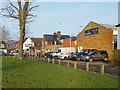
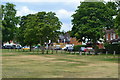
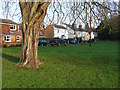
Houses by St John's Lye
Houses beside St John's Lye, a large open access area between the village and the railway line to the south.
Image: © Alan Hunt
Taken: 24 Feb 2016
0.01 miles
2
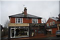
St John's, Surrey
Business premises beside St John's Lye.
Image: © Alan Hunt
Taken: 23 Jan 2015
0.01 miles
4
St John's Lye, looking toward the shops
Image: © David Martin
Taken: 1 Jul 2017
0.02 miles
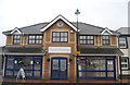
8

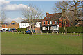
St John's Memorial Hall
The new Memorial Hall on St John's Lye. A vast improvement on the old hall, see Image
Image: © Alan Hunt
Taken: 24 Feb 2016
0.05 miles
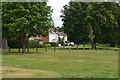
9
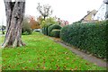
St John's Lye
The houses at the end of Warwick Road along the edge of St John's Lye.
Image: © Alan Hunt
Taken: 23 Jan 2015
0.05 miles