IMAGES TAKEN NEAR TO
Dale View, WOKING, GU21 7QD
Introduction
This page details the photographs taken nearby to Dale View, GU21 7QD by members of the Geograph project.
The Geograph project started in 2005 with the aim of publishing, organising and preserving representative images for every square kilometre of Great Britain, Ireland and the Isle of Man.

There are currently over 7.5m images from over14,400 individuals and you can help contribute to the project by visiting https://www.geograph.org.uk
Image Map
Images are licensed for reuse under creativecommons.org/licenses/by-sa/2.0
Notes
- Clicking on the map will re-center to the selected point.
- The higher the marker number, the further away the image location is from the centre of the postcode.
Image Listing (55 Images Found)
Images are licensed for reuse under creativecommons.org/licenses/by-sa/2.0
Image
Details
Distance
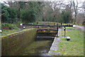
1
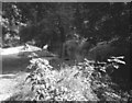
St. John's Lock No 8, Basingstoke Canal
Image: © Dr Neil Clifton
Taken: 25 Aug 1980
0.08 miles
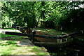
2
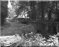
St. John's Bottom Lock No 7
The St. John's flight of five locks (Nos 7 to 11 inlusive) are sometimes referred to as the Goldsworth locks, especially in older sources.
Image: © Dr Neil Clifton
Taken: 25 Aug 1980
0.08 miles
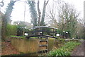
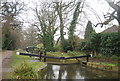
6
Basingstoke Canal
Lock to the north of St.John's.
Image: © Peter Trimming
Taken: 29 Jun 2019
0.08 miles
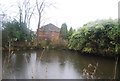
9
Firgrove
Residential cul-de-sac in St John's, an upmarket Woking suburb.
Image: © Colin Smith
Taken: 21 Mar 2009
0.10 miles
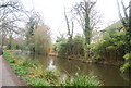
10
Looking across St John's Road from Langmans Lane
Image: © Shazz
Taken: 16 Nov 2014
0.10 miles