IMAGES TAKEN NEAR TO
Kingsway, WOKING, GU21 6NS
Introduction
This page details the photographs taken nearby to Kingsway, GU21 6NS by members of the Geograph project.
The Geograph project started in 2005 with the aim of publishing, organising and preserving representative images for every square kilometre of Great Britain, Ireland and the Isle of Man.

There are currently over 7.5m images from over14,400 individuals and you can help contribute to the project by visiting https://www.geograph.org.uk
Image Map
Images are licensed for reuse under creativecommons.org/licenses/by-sa/2.0
Notes
- Clicking on the map will re-center to the selected point.
- The higher the marker number, the further away the image location is from the centre of the postcode.
Image Listing (52 Images Found)
Images are licensed for reuse under creativecommons.org/licenses/by-sa/2.0
Image
Details
Distance
2
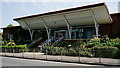
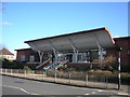
Surrey History Centre
Located in Goldsworth Road, Woking.
Image: © Peter Trimming
Taken: 29 Jun 2019
0.14 miles
3
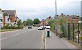
Mabel Street, Woking
Looking east along Mabel Street from the junction with Bridge Barn Lane.
Image: © Alan Hunt
Taken: 30 Sep 2015
0.15 miles
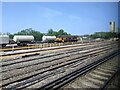
4
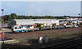
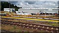
Woking Up Yard
The Balfour Beatty sidings at Woking are seen with engineers' vehicles present.
Image: © Gareth James
Taken: 24 Sep 2016
0.15 miles
5
Surrey History Centre
The county record office and local studies library.
Image: © Christopher Hilton
Taken: 3 Mar 2015
0.15 miles
7
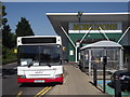
Transport Connection
Local Abellio-managed bus stopping at the busy Morrisons superstore in central Woking.
www.woking.gov.uk
Image: © Colin Smith
Taken: 24 Jul 2012
0.17 miles
8
Railtour at Woking
UK Railtours' Purbeck Adventurer tour from Tonbridge to Swanage is seen in Woking with class 73 locomotives 73109 and 73107 in charge.
Image: © Gareth James
Taken: 24 Sep 2016
0.17 miles
9
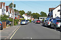
Goldsworth Road, Woking
The road leads away westwards out of the town centre. The development on the left is ‘The Old Dairy’.
Image: © Derek Harper
Taken: 14 Jun 2010
0.18 miles
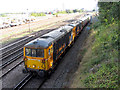
10
Goods train in sidings west of Woking station, class 69, no. 69001 Mayflower
Image: © Rob Purvis
Taken: 27 May 2023
0.18 miles