IMAGES TAKEN NEAR TO
Goldsworth Road, WOKING, GU21 6LE
Introduction
This page details the photographs taken nearby to Goldsworth Road, GU21 6LE by members of the Geograph project.
The Geograph project started in 2005 with the aim of publishing, organising and preserving representative images for every square kilometre of Great Britain, Ireland and the Isle of Man.

There are currently over 7.5m images from over14,400 individuals and you can help contribute to the project by visiting https://www.geograph.org.uk
Image Map
Images are licensed for reuse under creativecommons.org/licenses/by-sa/2.0
Notes
- Clicking on the map will re-center to the selected point.
- The higher the marker number, the further away the image location is from the centre of the postcode.
Image Listing (188 Images Found)
Images are licensed for reuse under creativecommons.org/licenses/by-sa/2.0
Image
Details
Distance
1
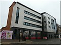
Woking Fire Station: late December 2021
Image: © Basher Eyre
Taken: 30 Dec 2021
0.01 miles
4
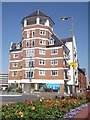
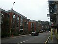
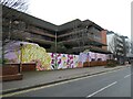
Changing Woking
Another new apartment block in central Woking. This one is at the corner of Church Street and Goldsworth Road, close to the railway station for commuting to London.
www.woking.gov.uk
Image: © Colin Smith
Taken: 24 Jul 2012
0.02 miles
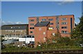
8
The skill of building tower blocks
UPDATE: See Image for a similar view taken just over two years later.
Image: © Fernweh
Taken: 16 Jun 2018
0.05 miles