IMAGES TAKEN NEAR TO
Victoria Way, GU21 6EX
Introduction
This page details the photographs taken nearby to Victoria Way, GU21 6EX by members of the Geograph project.
The Geograph project started in 2005 with the aim of publishing, organising and preserving representative images for every square kilometre of Great Britain, Ireland and the Isle of Man.

There are currently over 7.5m images from over14,400 individuals and you can help contribute to the project by visiting https://www.geograph.org.uk
Image Map
Images are licensed for reuse under creativecommons.org/licenses/by-sa/2.0
Notes
- Clicking on the map will re-center to the selected point.
- The higher the marker number, the further away the image location is from the centre of the postcode.
Image Listing (336 Images Found)
Images are licensed for reuse under creativecommons.org/licenses/by-sa/2.0
Image
Details
Distance
1
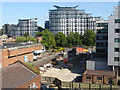
Woking townscape
The view southeast from the Toys-R-Us car park. The building site in the foreground marks the position of the old Post Office which was closed a number of years ago. Beyond is Cawsey Way with Boots the chemist on the corner of Commercial Way and the Centrum building providing the backdrop.
Image: © Alan Hunt
Taken: 16 May 2015
0.01 miles
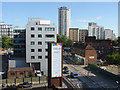
2
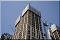
Woking
Victoria Square development, scheduled to be completed in 2020.
Image: © Peter Trimming
Taken: 29 Jun 2019
0.01 miles
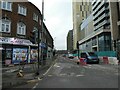
3
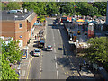
Cawsey Way, Woking
Looking along Cawsey Way from the Toys-R-Us car park with Wolsey Place shopping mall off to the left.
Image: © Alan Hunt
Taken: 16 May 2015
0.03 miles
4
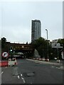
Looking towards a railway bridge from the High Street
Image: © Basher Eyre
Taken: 30 Dec 2021
0.03 miles
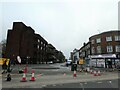
5
Road works at the bottom of the High Street
Image: © Basher Eyre
Taken: 30 Dec 2021
0.03 miles
6
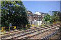
Buildings and rails on the approach to Woking station from the west
Image: © Rob Purvis
Taken: 27 May 2023
0.03 miles
8

Victoria Square
An extreme telephoto view of the towers of Victoria Square in central Woking, around 10km away, taken from The Mount above Guildford.
Image: © Ian Capper
Taken: 2 Dec 2021
0.03 miles
9
Woking townscape
The view south from the Toys-R-Us car park with the training tower of the firestation in the foreground with Guildford Road beyond. Much of this area has been designated for a major re-development including the firestation.
Image: © Alan Hunt
Taken: 16 May 2015
0.03 miles
10
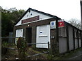
Woking Railway Athletic Club, Goldsworth Road
Image: © Basher Eyre
Taken: 30 Dec 2021
0.03 miles