IMAGES TAKEN NEAR TO
High Street, WOKING, GU21 6BL
Introduction
This page details the photographs taken nearby to High Street, GU21 6BL by members of the Geograph project.
The Geograph project started in 2005 with the aim of publishing, organising and preserving representative images for every square kilometre of Great Britain, Ireland and the Isle of Man.

There are currently over 7.5m images from over14,400 individuals and you can help contribute to the project by visiting https://www.geograph.org.uk
Image Map
Images are licensed for reuse under creativecommons.org/licenses/by-sa/2.0
Notes
- Clicking on the map will re-center to the selected point.
- The higher the marker number, the further away the image location is from the centre of the postcode.
Image Listing (390 Images Found)
Images are licensed for reuse under creativecommons.org/licenses/by-sa/2.0
Image
Details
Distance
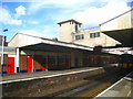
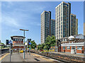
2
Woking Station
The western end of platform 1 at Woking Station. In the left background are Victoria Square Towers 1 and 2 with Woking Hilton just visible behind - all are due for completion in 2022. On the right is Export House, completed in 1974 and former headquarters of British American Tobacco, from 1976 to 1997. Prior to the construction of the other three buildings it was the tallest building in Woking.
Image: © Ian Capper
Taken: 17 Jun 2022
0.01 miles
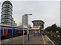
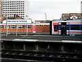
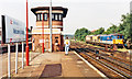
3
Woking Station
The western end of platforms 2 and 4 at Woking Station, with the 1930s grade II listed signal box on the left - see https://historicengland.org.uk/listing/the-list/list-entry/1236967?section=official-list-entry. In the right background are Victoria Square Towers 1 and 2 with Woking Hilton just visible behind - all are due for completion in 2022.
Image: © Ian Capper
Taken: 17 Jun 2022
0.01 miles
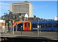
6
Waiting for the right of way at Woking
The guard of a train from the Exeter/Salisbury line waits for a green signal to allow progress to Waterloo.
Image: © John Lucas
Taken: 13 Jun 2001
0.02 miles
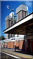
7
Woking Station: signalbox and class 73 electro-diesels, 1992
View westward at the west end of the Fast line platforms, towards Basingstoke etc., also Guildford and Portsmouth: ex-LSWR Waterloo - the West main lines, junction for Portsmouth. The large, prominent power-signalbox dates from 6/37, at the time the station was rebuilt in connection with the electrification of the Portsmouth line. It was in use until 8/97 and has been preserved as a Listed Building. In the siding on the right are three Class 73 electro-diesel locomotives - in contrasting liveries, the one in Pullman colours is No. 73.101.
Image: © Ben Brooksbank
Taken: 9 Jun 1992
0.02 miles
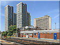
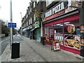
8
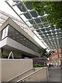
Albion Square, Woking
See also Image The canopy, 9.5 metres above the entrance to Woking Station, was erected in 2007, and includes 272 solar panels; Woking is in the vanguard of green technology. The older building in the background is at the start of Chertsey Road. On the left is Albion House, an office block.
Image: © Derek Harper
Taken: 14 Jun 2010
0.02 miles