IMAGES TAKEN NEAR TO
Victoria Way, WOKING, GU21 6AL
Introduction
This page details the photographs taken nearby to Victoria Way, GU21 6AL by members of the Geograph project.
The Geograph project started in 2005 with the aim of publishing, organising and preserving representative images for every square kilometre of Great Britain, Ireland and the Isle of Man.

There are currently over 7.5m images from over14,400 individuals and you can help contribute to the project by visiting https://www.geograph.org.uk
Image Map
Images are licensed for reuse under creativecommons.org/licenses/by-sa/2.0
Notes
- Clicking on the map will re-center to the selected point.
- The higher the marker number, the further away the image location is from the centre of the postcode.
Image Listing (243 Images Found)
Images are licensed for reuse under creativecommons.org/licenses/by-sa/2.0
Image
Details
Distance
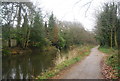
1
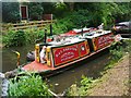
Woking - Narrowboat Gathering 2016
Atlantic No. 3 from Aylesbury on the Basingstoke Canal.
Image: © Colin Smith
Taken: 7 Aug 2016
0.01 miles
2
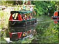
Woking - Narrowboat Gathering 2016
Boat trip on the Basingstoke Canal, viewing the assembled narrowboats from the water.
Image: © Colin Smith
Taken: 7 Aug 2016
0.02 miles

4
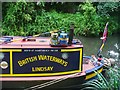
Woking - Narrowboat Gathering 2016
Lindsay on display on the Basingstoke Canal.
Image: © Colin Smith
Taken: 7 Aug 2016
0.03 miles
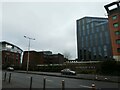
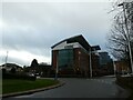
7
Approaching the junction of Victoria Way and Waterside
Image: © Basher Eyre
Taken: 30 Dec 2021
0.04 miles
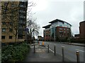
8
Looking from Victoria Way into Waterside
Image: © Basher Eyre
Taken: 30 Dec 2021
0.04 miles