IMAGES TAKEN NEAR TO
Albert Drive, WOKING, GU21 5UB
Introduction
This page details the photographs taken nearby to Albert Drive, GU21 5UB by members of the Geograph project.
The Geograph project started in 2005 with the aim of publishing, organising and preserving representative images for every square kilometre of Great Britain, Ireland and the Isle of Man.

There are currently over 7.5m images from over14,400 individuals and you can help contribute to the project by visiting https://www.geograph.org.uk
Image Map
Images are licensed for reuse under creativecommons.org/licenses/by-sa/2.0
Notes
- Clicking on the map will re-center to the selected point.
- The higher the marker number, the further away the image location is from the centre of the postcode.
Image Listing (7 Images Found)
Images are licensed for reuse under creativecommons.org/licenses/by-sa/2.0
Image
Details
Distance
7
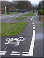
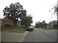
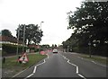
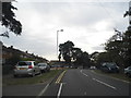
Albert Drive, Sheerwater
Through route in a suburb of Woking. The wide pavements are ideal for division between cyclists and pedestrians - even if some do cross over the line!
Image: © Colin Smith
Taken: 12 Feb 2011
0.24 miles