IMAGES TAKEN NEAR TO
Hanbury Path, WOKING, GU21 5RB
Introduction
This page details the photographs taken nearby to Hanbury Path, GU21 5RB by members of the Geograph project.
The Geograph project started in 2005 with the aim of publishing, organising and preserving representative images for every square kilometre of Great Britain, Ireland and the Isle of Man.

There are currently over 7.5m images from over14,400 individuals and you can help contribute to the project by visiting https://www.geograph.org.uk
Image Map
Images are licensed for reuse under creativecommons.org/licenses/by-sa/2.0
Notes
- Clicking on the map will re-center to the selected point.
- The higher the marker number, the further away the image location is from the centre of the postcode.
Image Listing (7 Images Found)
Images are licensed for reuse under creativecommons.org/licenses/by-sa/2.0
Image
Details
Distance
6
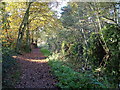
Basingstoke Canal, Sheerwater, Woking
Image: © David Griffiths
Taken: 10 Nov 2004
0.19 miles
7
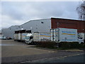
West Horsley Dairy
Not in West Horsley, but warehousing on a modern industrial estate in Sheerwater, Woking - some 10 kilometres north-west of West Horsley village.
www.westhorsleydairy.co.uk
Image: © Colin Smith
Taken: 12 Feb 2011
0.24 miles