IMAGES TAKEN NEAR TO
Martyrs Lane, WOKING, GU21 5NJ
Introduction
This page details the photographs taken nearby to Martyrs Lane, GU21 5NJ by members of the Geograph project.
The Geograph project started in 2005 with the aim of publishing, organising and preserving representative images for every square kilometre of Great Britain, Ireland and the Isle of Man.

There are currently over 7.5m images from over14,400 individuals and you can help contribute to the project by visiting https://www.geograph.org.uk
Image Map
Images are licensed for reuse under creativecommons.org/licenses/by-sa/2.0
Notes
- Clicking on the map will re-center to the selected point.
- The higher the marker number, the further away the image location is from the centre of the postcode.
Image Listing (12 Images Found)
Images are licensed for reuse under creativecommons.org/licenses/by-sa/2.0
Image
Details
Distance
3
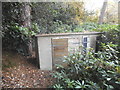
Storage unit on Martyr's Lane, Sheerwater
Oddly the doors didn't even have locks so were permanently open.
Image: © David Howard
Taken: 6 Nov 2016
0.11 miles
4
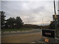
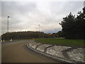
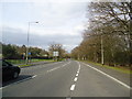
The Paragon Roundabout, Sheerwater
Chertsey Road southbound appeared to be being resurfaced and was closed to traffic, everything was diverted along Martyrs Lane.
Image: © David Howard
Taken: 6 Nov 2016
0.11 miles
10
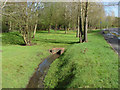
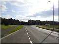
Drain by the A320
A drainage channel on the green alongside the A320. This area is part of the Mclaren landscaping scheme.
Image: © Alan Hunt
Taken: 8 Apr 2014
0.16 miles