IMAGES TAKEN NEAR TO
Pinewood Close, WOKING, GU21 5NG
Introduction
This page details the photographs taken nearby to Pinewood Close, GU21 5NG by members of the Geograph project.
The Geograph project started in 2005 with the aim of publishing, organising and preserving representative images for every square kilometre of Great Britain, Ireland and the Isle of Man.

There are currently over 7.5m images from over14,400 individuals and you can help contribute to the project by visiting https://www.geograph.org.uk
Image Map
Images are licensed for reuse under creativecommons.org/licenses/by-sa/2.0
Notes
- Clicking on the map will re-center to the selected point.
- The higher the marker number, the further away the image location is from the centre of the postcode.
Image Listing (38 Images Found)
Images are licensed for reuse under creativecommons.org/licenses/by-sa/2.0
Image
Details
Distance
1
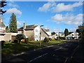
Woking - Brackendene Close
Detached houses could be 1970's.
Image: © James Emmans
Taken: 11 Feb 2018
0.06 miles

3

Bedser Trail, Horsell Common
The newly created disabled access path through the Woodham Common area of Horsell Common, dedicated to the memory of Sir Alec and Eric Bedser, the cricketing twins who lived locally and were supporters of the Horsell Common Preservation Society.
Image: © Alan Hunt
Taken: 27 Apr 2015
0.10 miles
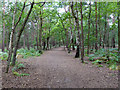
7
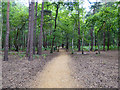
Surfaced path, Horsell Common
The Bedser Trail, a 1.2 km loop from and to a car park on Monument Road, opened in 2012 and made where no path was before. Consequently it is not very well mapped.
Image: © Robin Webster
Taken: 2 Aug 2020
0.17 miles
8

Surfaced path, Horsell Common
The Bedser Trail, a 1.2 km loop from and to a car park on Monument Road, opened in 2012 and made where no path was before. Consequently it is not very well mapped.
Image: © Robin Webster
Taken: 2 Aug 2020
0.17 miles
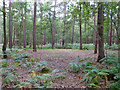
9
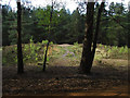
Tumulus, Horsell Common
The Bronze Age tumulus on the Woodham Common area of Horsell Common.
Image: © Alan Hunt
Taken: 27 Apr 2015
0.17 miles
10
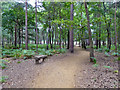
Surfaced path, Horsell Common
The Bedser Trail, a 1.2 km loop from and to a car park on Monument Road, opened in 2012 and made where no path was before. Consequently it is not very well mapped.
Image: © Robin Webster
Taken: 2 Aug 2020
0.18 miles