IMAGES TAKEN NEAR TO
Board School Road, WOKING, GU21 5HD
Introduction
This page details the photographs taken nearby to Board School Road, GU21 5HD by members of the Geograph project.
The Geograph project started in 2005 with the aim of publishing, organising and preserving representative images for every square kilometre of Great Britain, Ireland and the Isle of Man.

There are currently over 7.5m images from over14,400 individuals and you can help contribute to the project by visiting https://www.geograph.org.uk
Image Map
Images are licensed for reuse under creativecommons.org/licenses/by-sa/2.0
Notes
- Clicking on the map will re-center to the selected point.
- The higher the marker number, the further away the image location is from the centre of the postcode.
Image Listing (133 Images Found)
Images are licensed for reuse under creativecommons.org/licenses/by-sa/2.0
Image
Details
Distance
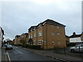
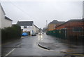
2
Looking from North Road into Board School Road
Image: © Basher Eyre
Taken: 30 Dec 2021
0.05 miles
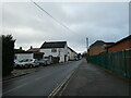
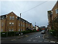
3
Boundary Road, Woking
The terrace along the south side of Boundary Road by the junction with Chertsey Road.
Image: © Alan Hunt
Taken: 7 May 2016
0.05 miles
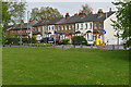
4

Tyre centre, Woking
The national Tyre centre near the junction of Boundary Road with Chertsey Road.
Image: © Alan Hunt
Taken: 7 May 2016
0.05 miles
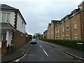
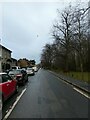
6
Electricity sub-station in Boundary Road
Image: © Basher Eyre
Taken: 30 Dec 2021
0.06 miles