IMAGES TAKEN NEAR TO
Stanley Road, WOKING, GU21 5EW
Introduction
This page details the photographs taken nearby to Stanley Road, GU21 5EW by members of the Geograph project.
The Geograph project started in 2005 with the aim of publishing, organising and preserving representative images for every square kilometre of Great Britain, Ireland and the Isle of Man.

There are currently over 7.5m images from over14,400 individuals and you can help contribute to the project by visiting https://www.geograph.org.uk
Image Map
Images are licensed for reuse under creativecommons.org/licenses/by-sa/2.0
Notes
- Clicking on the map will re-center to the selected point.
- The higher the marker number, the further away the image location is from the centre of the postcode.
Image Listing (288 Images Found)
Images are licensed for reuse under creativecommons.org/licenses/by-sa/2.0
Image
Details
Distance
1
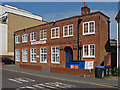
Former drill hall, Woking
The youth centre in Walton Road occupies a former drill hall dating back to the Great War when it was used by the Surrey Yeomanary (B squadron) and the 5th Battalion Royal West Surrey Regiment (H company).
Image: © Alan Hunt
Taken: 23 Jun 2014
0.02 miles

5
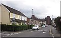
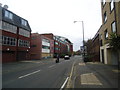
Walton Road, Woking
Leading towards the town centre. In the rear rises Image Taken at the crossroads junction with Portugal Road.
Image: © Derek Harper
Taken: 10 May 2013
0.06 miles
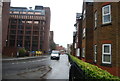
9
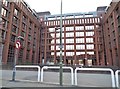
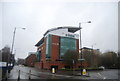
Dukes Court on Stanley Road, Woking
This is around half the total building, there are two more views included here.
Image: © David Howard
Taken: 9 Oct 2016
0.08 miles