IMAGES TAKEN NEAR TO
Boundary Road, WOKING, GU21 5BT
Introduction
This page details the photographs taken nearby to Boundary Road, GU21 5BT by members of the Geograph project.
The Geograph project started in 2005 with the aim of publishing, organising and preserving representative images for every square kilometre of Great Britain, Ireland and the Isle of Man.

There are currently over 7.5m images from over14,400 individuals and you can help contribute to the project by visiting https://www.geograph.org.uk
Image Map
Images are licensed for reuse under creativecommons.org/licenses/by-sa/2.0
Notes
- Clicking on the map will re-center to the selected point.
- The higher the marker number, the further away the image location is from the centre of the postcode.
Image Listing (100 Images Found)
Images are licensed for reuse under creativecommons.org/licenses/by-sa/2.0
Image
Details
Distance

2
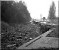
The Basingstoke Canal at Woking
The sad state of this waterway in 1973. Since then it has been restored and is now again navigable.
Image: © Dr Neil Clifton
Taken: 24 Mar 1973
0.04 miles
3
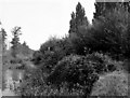
View east from Chertsey Road Bridge, Basingstoke Canal
Showing the jungle that faced canal restorers on this length in 1980.
Image: © Dr Neil Clifton
Taken: 25 Aug 1980
0.04 miles


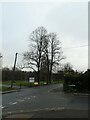
10
Crossroads of Courtenay, Board School and North Roads
Image: © Basher Eyre
Taken: 30 Dec 2021
0.07 miles