IMAGES TAKEN NEAR TO
High Street, WOKING, GU21 4UB
Introduction
This page details the photographs taken nearby to High Street, GU21 4UB by members of the Geograph project.
The Geograph project started in 2005 with the aim of publishing, organising and preserving representative images for every square kilometre of Great Britain, Ireland and the Isle of Man.

There are currently over 7.5m images from over14,400 individuals and you can help contribute to the project by visiting https://www.geograph.org.uk
Image Map
Images are licensed for reuse under creativecommons.org/licenses/by-sa/2.0
Notes
- Clicking on the map will re-center to the selected point.
- The higher the marker number, the further away the image location is from the centre of the postcode.
Image Listing (23 Images Found)
Images are licensed for reuse under creativecommons.org/licenses/by-sa/2.0
Image
Details
Distance
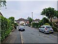
1
Thornash Road
Looking west along Thornash Road towards the site of the former farm that gave this road its name.
Image: © Alan Hunt
Taken: 23 Apr 2013
0.07 miles
2
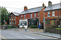
Horsell High Street
Shops in former houses on the High Street in Horsell Village.
Image: © Alan Hunt
Taken: 14 Sep 2015
0.10 miles
3
Thornash Way
The junction of Thornash Way with South Road. The buildings of Thornash Farm occupied the site where Thornash Road joins the High Street.
Image: © Alan Hunt
Taken: 23 Apr 2013
0.13 miles
4
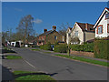
South Road, Horsell
An Edwardian terrace on South Road, Horsell. This was called Deep Lane in the 19th century when this area was covered by the fields of Thornash Farm.
Image: © Alan Hunt
Taken: 23 Apr 2013
0.14 miles
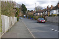
6
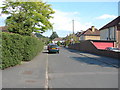
Thornash Road, Horsell
A view along Thornash Road from its junction with South Road.
Image: © Alan Hunt
Taken: 2 Jul 2011
0.15 miles
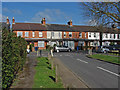
7
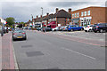
Horsell High Street
The main shopping arcade in the High Street.
Image: © Alan Hunt
Taken: 14 Sep 2015
0.15 miles
8
Bullbeggars Lane
A residential road that runs from Horsell to the Sythwood area of Goldsworth Park.
Image: © Alan Hunt
Taken: 15 Apr 2013
0.19 miles
9
Hill Close, Horsell
Hill Close, a cul-de-sac off Meadway Drive. There is a footpath between the houses at the end which leads into the Queen Elizabeth Gardens and thence to the High Street.
Image: © Alan Hunt
Taken: 30 Mar 2016
0.20 miles
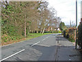
10
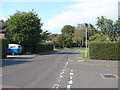
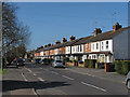
South Road, Horsell
A view along South Road towards Horsell Common. The side road in the foreground is Thornash Road.
Image: © Alan Hunt
Taken: 2 Jul 2011
0.21 miles