IMAGES TAKEN NEAR TO
Harelands Lane, WOKING, GU21 4NU
Introduction
This page details the photographs taken nearby to Harelands Lane, GU21 4NU by members of the Geograph project.
The Geograph project started in 2005 with the aim of publishing, organising and preserving representative images for every square kilometre of Great Britain, Ireland and the Isle of Man.

There are currently over 7.5m images from over14,400 individuals and you can help contribute to the project by visiting https://www.geograph.org.uk
Image Map
Images are licensed for reuse under creativecommons.org/licenses/by-sa/2.0
Notes
- Clicking on the map will re-center to the selected point.
- The higher the marker number, the further away the image location is from the centre of the postcode.
Image Listing (54 Images Found)
Images are licensed for reuse under creativecommons.org/licenses/by-sa/2.0
Image
Details
Distance
1
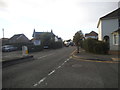
Well Lane at the junction of Arthurs Bridge Road
Image: © David Howard
Taken: 16 Oct 2016
0.03 miles
2
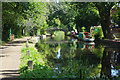
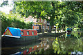
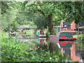
Basingstoke Canal west of Arthur's Bridge
A couple of narrowboats are moored outside the Bridge Barn pub/restaurant with Arthurs' Bridge in the background.
Image: © Stephen McKay
Taken: 29 Aug 2019
0.04 miles
3
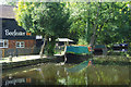
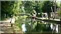
Basingstoke Canal and the Bridge Barn
The Bridge Barn is a pub/restaurant, part of Whitbread's Beefeater Chain. The Beefeater logo is reflected in the water in front of 'Kitty' which is owned by the Basingstoke Canal Society and is moored with the pub's permission. This leafy stretch is characteristic of the Basingstoke Canal, belieing the surrounding urban environment.
Image: © Stephen McKay
Taken: 29 Aug 2019
0.04 miles
4
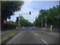
Traffic lights on A324 at junction of Arthurs Bridge Road
Image: © David Howard
Taken: 1 May 2011
0.04 miles
5
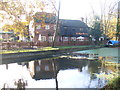
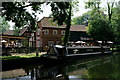
Basingstoke Canal and the Bridge Barn
Here close to Arthur's Bridge are moorings for the Bridge Barn, a former farm building parts of which date from the 16th century. It became a Beefeater pub/restaurant in the 1980s - Beefeater is a national Whitbread brand.
Image: © Stephen McKay
Taken: 29 Aug 2019
0.04 miles
7
Well Lane, Horsell
Looking south towards the traffic lights on Lockfield Drive. Arthur's Bridge Road is on the left near the lights.
Image: © Alan Hunt
Taken: 30 Sep 2015
0.05 miles
8
Bridge Barn, Woking
Popular chain restaurant beside the Basingstoke Canal in western Woking.
www.woking.gov.uk
Image: © Colin Smith
Taken: 7 Dec 2011
0.05 miles
9
Basingstoke Canal Woking
View looking east towards Arthur's Bridge. It carries Bridge Barn Lane over the canal.
Image: © Richard Rogerson
Taken: 19 Aug 2021
0.05 miles
10
Basingstoke Canal
Narrow boat moored beside the Beefeater.
Image: © Peter Trimming
Taken: 29 Jun 2019
0.05 miles