IMAGES TAKEN NEAR TO
Brewery Road, WOKING, GU21 4NA
Introduction
This page details the photographs taken nearby to Brewery Road, GU21 4NA by members of the Geograph project.
The Geograph project started in 2005 with the aim of publishing, organising and preserving representative images for every square kilometre of Great Britain, Ireland and the Isle of Man.

There are currently over 7.5m images from over14,400 individuals and you can help contribute to the project by visiting https://www.geograph.org.uk
Image Map
Images are licensed for reuse under creativecommons.org/licenses/by-sa/2.0
Notes
- Clicking on the map will re-center to the selected point.
- The higher the marker number, the further away the image location is from the centre of the postcode.
Image Listing (77 Images Found)
Images are licensed for reuse under creativecommons.org/licenses/by-sa/2.0
Image
Details
Distance
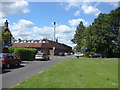
1
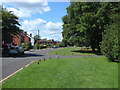
Horsell Moor
A view along Horsell Moor showing the short connecting road between Horsell Moor and Brewery Road
Image: © Alan Hunt
Taken: 24 Jul 2011
0.04 miles
2
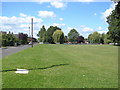
Horsell Moor
A view along Horsell Moor with the children's play area at the western end.
Image: © Alan Hunt
Taken: 24 Jul 2011
0.07 miles
3
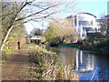
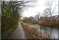
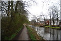
Basingstoke Canal Towpath, Woking
Pleasant waterside walk in central Woking with the Cap Gemini office block in the background.
www.woking.gov.uk
Image: © Colin Smith
Taken: 7 Dec 2011
0.10 miles
4
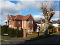
Woking - Detached Houses in Private Road
Houses on Horsell Park.
Image: © James Emmans
Taken: 11 Feb 2018
0.10 miles
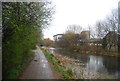
7
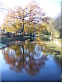
Basingstoke Canal, Woking
Tree reflected in the peaceful waters of the canal in western Woking.
www.woking.gov.uk
Image: © Colin Smith
Taken: 7 Dec 2011
0.11 miles
9
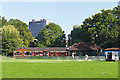
Horsell sports ground
The pavilion in the sports ground on Arthur's Bridge Road. The tall building in the background is the former headquarters of British American Tobacco in the centre of Woking.
Image: © Alan Hunt
Taken: 30 Sep 2015
0.12 miles
10
Horsell Moor
The western end of Horsell Moor. The building with the stack is White's Laundry.
Image: © Alan Hunt
Taken: 24 Jul 2011
0.12 miles