IMAGES TAKEN NEAR TO
Graylands Close, WOKING, GU21 4LR
Introduction
This page details the photographs taken nearby to Graylands Close, GU21 4LR by members of the Geograph project.
The Geograph project started in 2005 with the aim of publishing, organising and preserving representative images for every square kilometre of Great Britain, Ireland and the Isle of Man.

There are currently over 7.5m images from over14,400 individuals and you can help contribute to the project by visiting https://www.geograph.org.uk
Image Map
Images are licensed for reuse under creativecommons.org/licenses/by-sa/2.0
Notes
- Clicking on the map will re-center to the selected point.
- The higher the marker number, the further away the image location is from the centre of the postcode.
Image Listing (99 Images Found)
Images are licensed for reuse under creativecommons.org/licenses/by-sa/2.0
Image
Details
Distance
1
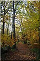
Path Through Horsell Moor
Image is owned and managed by the Horsell Common Preservation Society http://www.horsellcommon.org.uk/
Image: © Glyn Baker
Taken: 10 Nov 2018
0.07 miles
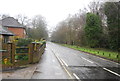
2
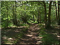
Horsell Moor
Footpath through the woods that cover this part of Horsell Moor
Image: © Alan Hunt
Taken: 24 Jul 2011
0.10 miles
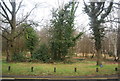
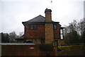
9
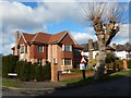
Woking - Detached Houses in Private Road
Houses on Horsell Park.
Image: © James Emmans
Taken: 11 Feb 2018
0.15 miles
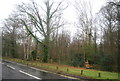
10
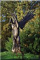
Launching Pegasus
This sculpture on Image was commissioned by the Horsell Common Preservation Society http://www.horsellcommon.org.uk/ in 2009 after a mini tornado killed the 250 year old tree two years previously.
Image: © Glyn Baker
Taken: 10 Nov 2018
0.16 miles