IMAGES TAKEN NEAR TO
Guernsey Farm Drive, WOKING, GU21 4BE
Introduction
This page details the photographs taken nearby to Guernsey Farm Drive, GU21 4BE by members of the Geograph project.
The Geograph project started in 2005 with the aim of publishing, organising and preserving representative images for every square kilometre of Great Britain, Ireland and the Isle of Man.

There are currently over 7.5m images from over14,400 individuals and you can help contribute to the project by visiting https://www.geograph.org.uk
Image Map
Images are licensed for reuse under creativecommons.org/licenses/by-sa/2.0
Notes
- Clicking on the map will re-center to the selected point.
- The higher the marker number, the further away the image location is from the centre of the postcode.
Image Listing (22 Images Found)
Images are licensed for reuse under creativecommons.org/licenses/by-sa/2.0
Image
Details
Distance

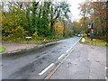
5
South Road
South Road bisects Image owned and managed by the Horsell Common Preservation Society http://www.horsellcommon.org.uk/
Image: © Glyn Baker
Taken: 10 Nov 2018
0.17 miles
7
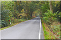
South Road, Horsell
South Road running through the wooded area of Horsell Common towards Littlewick Road.
Image: © Alan Hunt
Taken: 3 Nov 2015
0.19 miles
9
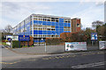
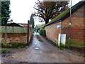
Woking High School, Horsell
The High School on Morton Road. The buildings date from about 1970.
Image: © Alan Hunt
Taken: 30 Mar 2016
0.20 miles
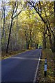
10
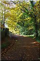
Autumn Colours in Cheapside
One of the leafly lanes of Surrey
Image: © Glyn Baker
Taken: 10 Nov 2018
0.20 miles