IMAGES TAKEN NEAR TO
Horsell Rise, WOKING, GU21 4BA
Introduction
This page details the photographs taken nearby to Horsell Rise, GU21 4BA by members of the Geograph project.
The Geograph project started in 2005 with the aim of publishing, organising and preserving representative images for every square kilometre of Great Britain, Ireland and the Isle of Man.

There are currently over 7.5m images from over14,400 individuals and you can help contribute to the project by visiting https://www.geograph.org.uk
Image Map
Images are licensed for reuse under creativecommons.org/licenses/by-sa/2.0
Notes
- Clicking on the map will re-center to the selected point.
- The higher the marker number, the further away the image location is from the centre of the postcode.
Image Listing (9 Images Found)
Images are licensed for reuse under creativecommons.org/licenses/by-sa/2.0
Image
Details
Distance

4
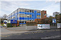
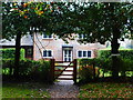
Woking High School, Horsell
The High School on Morton Road. The buildings date from about 1970.
Image: © Alan Hunt
Taken: 30 Mar 2016
0.18 miles
5
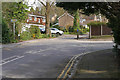
Morton Road, Horsell
The junction between Morton Road and Meadway Drive off to the right. The road beyond the junction is Ridgemount.
Image: © Alan Hunt
Taken: 30 Mar 2016
0.19 miles
6
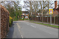
Meadway Drive, Horsell
The northeast end of Meadway Drive looking towards the Morton Road and the Ridgeway junction.
Image: © Alan Hunt
Taken: 30 Mar 2016
0.20 miles
8
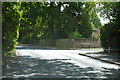
A3046 Kettlewell Hill
Towards central Woking, with Heathlands Close on the right.
Image: © Robin Webster
Taken: 2 Aug 2020
0.23 miles