IMAGES TAKEN NEAR TO
Ashton Road, WOKING, GU21 3QF
Introduction
This page details the photographs taken nearby to Ashton Road, GU21 3QF by members of the Geograph project.
The Geograph project started in 2005 with the aim of publishing, organising and preserving representative images for every square kilometre of Great Britain, Ireland and the Isle of Man.

There are currently over 7.5m images from over14,400 individuals and you can help contribute to the project by visiting https://www.geograph.org.uk
Image Map
Images are licensed for reuse under creativecommons.org/licenses/by-sa/2.0
Notes
- Clicking on the map will re-center to the selected point.
- The higher the marker number, the further away the image location is from the centre of the postcode.
Image Listing (24 Images Found)
Images are licensed for reuse under creativecommons.org/licenses/by-sa/2.0
Image
Details
Distance
1
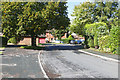
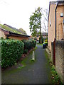
Tregarth Place, Goldsworth Park
A cul de sac off Kirkland Avenue in this large 1970s housing estate to the west of Woking.
Image: © Alan Hunt
Taken: 17 Sep 2015
0.05 miles
2
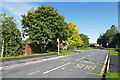
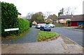
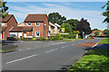
Kirkland Avenue, Goldsworth Park
Kirkland Avenue near the junction with Cliton Way.
Image: © Alan Hunt
Taken: 17 Sep 2015
0.07 miles
3
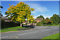
Robinia, Goldsworth Park
A Robinia by the junction of Tregarth Place with Kirkland Avenue.
Image: © Alan Hunt
Taken: 17 Sep 2015
0.08 miles
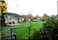
9
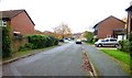
Hawkeswell Close, Goldsworth Park
The junction of Hawkeswell Close with Kirkland Avenue in this large 1970s housing estate to the west of Woking.
Image: © Alan Hunt
Taken: 17 Sep 2015
0.15 miles
10
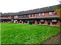
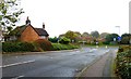
Terraced crescent of houses on Nethercote Avenue
Image: © Shazz
Taken: 16 Nov 2014
0.17 miles